BIG BANG NEWS
RESEARCH, TECHNOLOGY, SCIENCE, DIACHRONIC NEWS, COMMENTS, ,SPORTS,MUSIC,SKY AND STARS,AND MUSH MORE.

Αναζήτηση αυτού του ιστολογίου

Τετάρτη 5 Οκτωβρίου 2016

Hurricane Matthew from the Space Station

Oct. 4, 2016 - Update No. 2 - View of Matthew from the International Space Station

Cameras outside the International Space Station captured dramatic views of major Hurricane Matthew Oct. 3 as the orbital complex flew 250 miles over the storm at 4:15 p.m. EDT. Packing winds of 140 miles an hour as a Category 4 hurricane, Matthew was expected to pass over western Haiti and eastern Cuba Oct. 4 before charging north over the Bahamas Oct. 5 and potentially threatening the east coast of the United States later in the week.


Oct. 4, 2016 - Update No. 1 - NASA Sees Hurricane Matthew Making Landfall in Haiti

Hurricane Matthew made landfall in western Haiti during the morning hours of Oct. 4, and a NASA animation of NOAA's GOES-East satellite covered the monster storm.
satellite imagery animation of Hurricane Matthew
This animation of NOAA's GOES-East satellite imagery from Oct. 2 to Oct. 4, 2016, shows Hurricane Matthew moving through the Caribbean Sea and making landfall on Oct. 4 over western Haiti.

NOAA's GOES-East satellite provides continuous imagery of the Atlantic Ocean and eastern U.S. and has been keeping a close eye on powerful Hurricane Matthew. Infrared imagery shows Matthew's movements at night, while visible imagery shows Matthew's movements during the day. At NASA's Goddard Space Flight Center in Greenbelt, Maryland, both infrared and visible imagery were combined into an animation from Oct. 2 to Oct. 4. The animation ends just after Hurricane Matthew made landfall on Oct. 4 near Les Anglais in western Haiti about 7 a.m. EDT (1100 UTC). 

visible-light image of Hurricane Matthew
This visible-light image of Hurricane Matthew was taken from NOAA's GOES-East satellite at 7:45 a.m. EDT on Oct. 4, 2016, within the hour of landfall in western Haiti.
Credits: NASA/NOAA GOES Project

infrared image of Matthew from Aqua satellite
This infrared image of Matthew was taken from the MODIS instrument aboard NASA's Aqua satellite on Oct. 4, 2016, at 2:10 a.m. EDT (0610 UTC). Red indicates very cold cloud tops with the potential to generate very heavy rainfall.
Credits: NASA/NRL
A hurricane warning is in effect for Haiti; the Cuban provinces of Guantanamo, Santiago de Cuba, Holguin, Granma and Las Tunas; the southeastern Bahamas, including the Inaguas, Mayaguana, Acklins, Crooked Island, Long Cay and Ragged Island; the Central Bahamas, including Long Island, Exuma, Rum Cay, San Salvador and Cat Island; and the northwestern Bahamas, including the Abacos, Andros Island, Berry Islands, Bimini, Eleuthera, Grand Bahama Island and New Providence.
A tropical storm warning is in effect for the Dominican Republic from Barahona westward to the border with Haiti, Jamaica, and the Turks and Caicos Islands.
There are also hurricane and tropical storm watches in effect today, Oct. 4. A hurricane watch is in effect for the Cuban province of Camaguey. A tropical storm watch is in effect for the Dominican Republic from Puerto Plata westward to the border with Haiti.
On Oct. 4 at 2:10 a.m. EDT (0610 UTC), NASA's Aqua satellite passed over Matthew and analyzed the hurricane in infrared light to show temperatures. The MODIS, or Moderate Resolution Imaging Spectroradiometer, instrument aboard NASA's Aqua satellite revealed cloud top temperatures as cold or colder than minus 70 F (minus 56.6 C). NASA research indicates very cold cloud tops with the potential to generate very heavy rainfall.
At 8 a.m. EDT (1200 UTC) on Oct. 4 the eye of Hurricane Matthew was located inland Haiti near 18.4 degrees north latitude and 74.2 degrees west longitude. That's just 10 miles (15 km) east of Tiburon, Haiti, and about 125 miles (200 km) south of the eastern tip of Cuba.  
NOAA's National Hurricane Center (NHC) said Matthew was moving to the north near 9 mph (15 kph), and this general motion is expected to continue today.  A turn toward the north-northwest is expected by Wednesday, Oct. 5, followed by a northwest turn Wednesday night. On the forecast track, the eye of Matthew will move near or over portions of the southeastern and central Bahamas tonight and Wednesday, and approach the northwestern Bahamas Wednesday night.
Maximum sustained winds remain near 145 mph (230 kph) with higher gusts.  Matthew is a category 4 hurricane on the Saffir-Simpson Hurricane Wind Scale.  Some fluctuations in intensity are possible during the next couple of days, but Matthew is expected to remain a powerful hurricane through at least Wednesday night.
Hurricane-force winds extend outward up to 40 miles (65 km) from the center and tropical-storm-force winds extend outward up to 185 miles (295 km). The estimated minimum central pressure is 934 millibars.

Τρίτη 4 Οκτωβρίου 2016

Ο Ρωσος προεδρος Πούτιν ελευθερωνει άγρια ​​άλογα στην φυση (video)

„Diese Pferde sind praktisch von der Erde verschwunden“ - Putin entlässt Wildpferde in die Freiheit
Der russische Präsident Wladimir Putin hat gestern das staatliche Orenburgski-Naturschutzgebiet in der Orenburg-Region besucht, um zusammen mit Tierpflegern einige Przewalski-Pferde in ihren natürlichen Lebensraum zu entlassen. Das Naturschutzgebiet ist für das Programm zur Auswilderung dieser bedrohten Pferde bekannt.
Putin lockte die Pferde mit Hafer in die Freiheit und erklärte, dass es sich hierbei um „ein einmaliges Ereignis“ handele, da diese Pferde „praktisch von der Erde verschwunden“ sind. Nach der Auswilderung setzte sich der russische Präsident mit Mitwirkenden des Projekts für eine Tasse Tee zusammen.
Für deutsche Untertitel bitte die Untertitelfunktion auf Youtube aktivieren.

Δευτέρα 3 Οκτωβρίου 2016

Ο τυφώνας Μάθιου πλησιάζει απειλητικά την Καραϊβική--Hurricane Matthew Less Than 24 Hours From Catastrophic Haiti Strike; Hurricane Warnings in Jamaica, Cuba and Bahamas

Ο τυφώνας Μάθιου πλησιάζει απειλητικά την Καραϊβική


Δημοσιεύτηκε στις 3 Οκτ 2016
Ανησυχία επικρατεί στην Καραϊβική, καθώς ο τυφώνας Μάθιου πλησιάζει απειλητικά Τζαμάικα, Κούβα και Αϊτή.

Πρόκειται για ένα από τα πλέον ισχυρά φαινόμενα της τελευταίας δεκαετίας στην περιοχή, με ανέμους που φτάνουν τα 230 χιλιόμετρα την ώρα και κατακλυσμιαίες βροχοπτώσεις. 


Hurricane Matthew, the most powerful Atlantic tropical storm since 2007, was on a path to land a heavy punch on Jamaica, Cuba and Haiti, forecasters said.
"This is shaping up to be a devastating blow, especially to places like Haiti and Cuba," said Domenica Davis, a meteorologist for The Weather Channel.
IMAGE: Hurricane Matthew's projected track
Hurricane Matthew's projected track at 8 p.m. ET Sunday. Areas in red are under hurricane warnings. National Hurricane Center
At 5 a.m. ET on Monday, Matthew was a category 4 hurricane with maximum sustained winds near 130 mph, the National Hurricane Center said. It was 230 miles south-southeast of Kingston, Jamaica, which was already being swamped with torrents of rain, and it was moving north at about 6 mph.
The National Hurricane Center called Matthew "extremely dangerous," and conditions look favorable for it to maintain its strength, said Michael Lowry, a hurricane specialist for The Weather Channel.
"It's kind of a resilient hurricane — it hasn't really wavered much in terms of its strength," Lowry said Sunday night. "It's a little bit unusual to go 48 hours with a category 4 or 5 hurricane and not to see some sort of fluctuation."
The center of the storm was expected to approach southwestern Haiti and Jamaica on Monday. With it expected to remain a powerful storm into at least Tuesday, hurricane warnings were in effect for all of Jamaica and Haiti and for the Cuban provinces of Guantanamo, Santiago de Cuba, Holguin, Granma and Las Tunas.

Σάββατο 1 Οκτωβρίου 2016

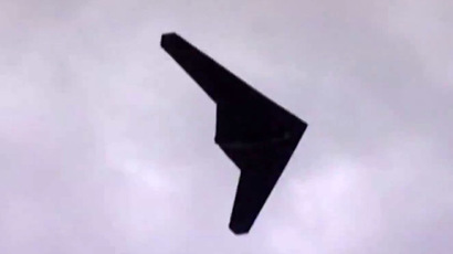
Iran unveils combat UAV based on captured US spy drone design(VIDEO)

Iran unveils combat UAV based on captured US spy drone design


A scale model of the US RQ-170 unmanned spy plane is displayed during a ceremony to mark the 33rd anniversary of the Islamic Revolution, in Tehran's Azadi square February 11, 2012. © Raheb Homavandi
Iranian engineers have weaponized the drone they built after reverse-engineering the American RQ-170 Sentinel, which the Islamic Republic captured in 2011, Iranian media reported.
The drone has high endurance and can carry a payload of four smart guided bombs, Press TV reports. The aircraft is dubbed Saeqeh (Tunderbolt) and was made public on Saturday by the Islamic Revolution Guards Corps (IRGC) as part of an exhibition of advanced military hardware.
The design of the new unmanned aerial vehicle (UAV) is based on the RQ-170 Sentinel, a US surveillance drone, which Iran captured in 2011. Earlier unarmed versions of the aircraft were demonstrated by the Iranians, with Pentagon officials describing it as inferior to the American version.
Commenting on the new weapon, IRGC’s Aerospace Division chief Brigadier General Amirali Hajizadeh said that he considered Iran one of the world’s top four drone producers.
Iran is pursuing self-reliance in military production, seeking to make an entire range of hardware domestically. The country’s ability to purchase foreign military technology is limited by international sanctions, which are meant to stall Iran’s progress in sensitive areas like rocketry.
Tehran insists that its military does not pose a threat to any foreign nation. But Iran is apparently irritated by the presence of US military assets close to its borders, and has been showing their displeasure in particular by staging maneuvers close to American warships deployed in the Strait of Hormuz lately. In January, it flew a large drone apparently capable of carrying air-to-surface missiles over the USS Harry S. Truman.

Footage has resurfaced online showing two freight trains collide head-on on a Californian track

Footage has resurfaced online showing two freight trains collide head-on on a Californian track. One of the freight trains was scheduled to pass the other, but the crew on-board the second train misread a signal. After a collision was inevitable both trains went into emergency stopping mode which reduced their speeds to approximately 30mph. All three crew-members on-board the second train then jumped out before impact, while the crew on the first train decided to withstand the crash. Miraculously, everyone involved survived but with various injuries. The cost of this accident is estimated to be about 5 million dollars.

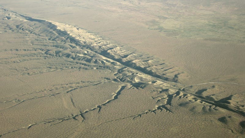
Massive Earthquake Along the San Andreas Fault Is Disturbingly Imminent


The USGS estimates a 1 in 100 chance of the San Andreas Fault rupturing between now and October 4. (Image: SanAndreasFault.org)

A series of quakes under the Salton Sea may be a signal that the San Andreas Fault is on the verge of buckling. For the next few days, the risk of a major earthquake along the fault is as high as 1 in 100. Which, holy crap.
The United States Geological Survey has been tracking a series of earthquakes near Bombay Beach, California. This “earthquake swarm” is happening under the Salton Sea, and over 140 events have been recorded since Monday September 26. The quakes range from 1.4 to 4.3 in magnitude, and are occurring at depths between 2.5 to 5.5 miles (4 to 9 km).


Quakes recorded under the Salton Sea on September 27, 2016. (Image: USGS)

For seismologists, these quakes could represent some seriously bad news. The swarm is located near a set of cross-faults that are connected to the southernmost end of the San Andreas Fault. Troublingly, some of these cross-faults could be adding stress to the San Andreas Fault when they shift and grind deep underground. Given this region’s history of major earthquakes, it’s got some people a bit nervous.
Calculations show that from now until October 4, the chance of a magnitude 7 or greater earthquake happening along the Southern San Andreas Fault is as high as 1 in 100, and as low as 1 in 3,000. On the plus side, the likelihood of it happening decreases with each passing day. These estimates are based on models developed to assess the probabilities of earthquakes and aftershocks in California.
“Swarm-like activity in this region has occurred in the past, so this week’s activity, in and of itself, is not necessarily cause for alarm,” cautions the USGS.
That being said, this is only the third swarm that has been recorded in this area since sensors were installed in 1932, and it’s much worse than the ones recorded in 2001 and 2009. This particular stretch of the San Andreas Fault hasn’t ruptured since 1680, and given that big quakes in this area happen about once every 150 to 200 years, this fault line is considerably overdue.


A big fear is that the rupturing of the southern portion of the San Andreas fault could cause a domino effect along the entire stretch, cracking the fault from Imperial County through to Los Angeles County. Another possibility is that the Salton Sea swarm could cause the nearby San Jacinto fault system to rupture,which would in turn trigger the collapse of the San Andreas Fault.
Should the Big One hit, it won’t be pretty. Models predict a quake across the southern half of California with a magnitude around 7.8. Such a quake would cause an estimated 1,800 deaths, 50,000 injuries, and over $200 billion in damage.
But as the USGS researchers point out, this is far from an inevitability. The swarm under the Salton Sea may subside, or fail to influence the gigantic fault nearby. Moreover, the estimates provided by the scientists are exactly that—estimates. The science of earthquake prediction is still very much in its infancy, and these models are very likely crunching away with insufficient data. No need to panic just yet.

A quake swarm in the Salton Sea that lasted over 24 hours from Monday into Tuesday has created a short-term increase in the risk of waking up the San Andreas fault.
“A swarm is when you have, in a tight geographic region, a cluster of earthquakes happen in rapid succession," says Kate Scharer, a research geologist with the U.S. Geological Survey. "It’s an area that often just has generic background seismicity but, for some reason, sort of pipes up for a while and lets off earthquakes.”
By the time all was said and done, over 200 earthquakes had been recorded in the more than day-long period.
The reason, Scharer says, is because the quake swarm happened below the southernmost tip of the San Andreas fault, an area that hasn’t produced a quake since 1680. They say that the odds of a magnitude-7 quake or larger happening in the southern area of the fault is as high as 1 in 100 and as low as 1 in 3,000.
“That’s related to the general statistics of how these swarms happen," says Scharer. "Some of the folks at the USGS collect data on this type of behavior, the swarm behavior, and then try to understand and model what you can expect from the future. So, in general, they would have similar forecasts, given that the magnitude distribution is fairly similar.”
The good news is that these odds decrease over time, but researchers say that it’s still a real enough risk to worry, and that a quake swarm like the one earlier this week are worth watching because, as Scharer notes, these smaller quakes could be what sets off a larger quake along San Andreas.
“Worldwide, you can see lots of cases where you have an earthquake on a subsidiary fault that’s not on the main strand that then is followed in short order by a larger rupture. The earthquakes that they had in Christchurch in New Zealand happened this way, or in kind of a bigger way, the Denali Fault rupture was kind of like that. We know that there’s some transfer of stress from these faults onto the main San Andreas due to their orientation, so there is some communication between them.”

Seismologists say the San Andreas fault is long overdue to rupture since a large-scale quake happens in the area every 150-200 years.

Mitsubishi GT-PHEV Concept - interior Exterior and Drive

The MITSUBISHI GT-PHEV Concept is a high-end next-generation crossover SUV that easily takes many road surface conditions in stride. Featuring Mitsubishi Motors Corporation (MMC)’s latest design language together with MMC’s advanced and proprietary electric and all-wheel control technologies, the MITSUBISHI GT-PHEV Concept empowers drivers to pilot their car with confidence under a wide range of driving conditions. It stirs the driver’s curiosity and sense of adventure as they seek to go further, as they seek to take a step beyond anything they have experienced before.
In its overall design, the MITSUBISHI GT-PHEV Concept projects the image of a “ground tourer” – a car made for cruising across a vast land – expressing Functional Beauty, Augmented Possibility, Sculptured Dynamism, Japanese Craftsmanship.
The front visage with its forceful presence employs MMC’s Dynamic Shield front design concept that portrays the front end’s function of protecting both people and the car. From the side, the MITSUBISHI GT-PHEV Concept uses horizontal lines to convey its high-end crossover SUV styling and vehicle stability. With a muscularity and intensity that gives the impression it has been carved from a single ingot of steel, the body is clothed in classy styling that flourishes sculptured dynamism highlighted by precise detailing.
Inside, the MITSUBISHI GT-PHEV Concept uses a horizontal dashboard that creates a spacious ambiance, making it easier for the driver to sense changes in vehicle attitude. Together with an instrument panel with a high center console, the cockpit-like interior wraps around its people, providing a sense of solace and security. Generous use of Burgundy*1 genuine leather trim, color coordinated with the exterior roof color is another touch in creating a classy and comfortable interior space.
  • *1 : A deep and rich reddish purple similar to that of wine
On the technology front, in addition to outstanding environmental performance MMC’s advanced triple-motor PHEV system delivers superior motive performance to empower drivers of any skill level to confidently follow new paths as they like through a multitude of different weather and road surface conditions, for an enjoyable and rewarding driving experience.
This PHEV system comprises a next-generation high-capacity drive battery package, three high-output and high-efficiency motors and an engine designed especially for the PHEV system featuring improved electricity generation performance and motive performance. This combination delivers the punchy performance ideal for a “ground tourer” and makes for comfortable driving on longer trips as well with an electric-only range of 120 km and a combined hybrid cruising range of over 1,200 km. The triple-motor powertrain, with one unit at the front and two at the rear, delivers a dramatic improvement in the performance of its full-time four-wheel drive powertrain and MMC’s own Super All Wheel Control (S-AWC) integrated vehicle dynamics control system, bringing new levels of handling stability.
The MITSUBISHI GT-PHEV Concept also adopts the latest in connected car technology in extracting its performance and functionality to the full. The technology feeds to the car route information as well as data on weather and road surface conditions acquired from information networks and from on-board sensors and cameras in order to closely manage energy consumption such as electricity consumption and fuel economy as well as to provide all-wheel control best-suited to many motoring situations.
  • MITSUBISHI GT-PHEV Concept (English ver.)
  • The Interview / Tsunehiro Kunimoto, Corporate General Manager of design office, Mitsubishi Motors
  •  
  •  

Σκοτώνοντας πέντε στρατιώτες και τραυματίζοντας 10 ένοπλη επίθεση στο βόρειο Μεξικό(video)


News of the World
Μεξικού δυνάμεις ασφαλείας Μεξικού δυνάμεις ασφαλείας
Τοπικό γραφείο αντιπροσωπείας αξίωση στο Μεξικό ανακοίνωσε την Παρασκευή 30 Σεπτεμβρίου / Σεπτεμβρίου ότι μια ένοπλη επίθεση σε στρατιωτική φάλαγγα στην πολιτεία Σιναλόα βόρειο τμήμα της χώρας, σκοτώνοντας πέντε στρατιώτες και τραυματίζοντας 10 άλλους, τουλάχιστον.
Η επίθεση έλαβε χώρα νωρίς το πρωί στα περίχωρα της πόλης της Κουλιακάν προπύργιο της συμμορίας «Σιναλόα», με επικεφαλής τον Joaquin Guzman El Chapo, ο οποίος συνελήφθη εκ νέου τον περασμένο Ιανουάριο.
Ένας υπάλληλος στο γραφείο του εισαγγελέα: «Ήταν μια ενέδρα προφανώς, πιστεύουμε ότι η επίθεση πραγματοποιήθηκε από μια τοπική συμμορία."
Guzman, τη στιγμή κρατείται σε μια φυλακή στη Σιουδάδ Χουάρες, μια βόρεια πόλη στα σύνορα των ΗΠΑ, εν αναμονή της έκδοσης με τις Ηνωμένες Πολιτείες.
Οι Ηνωμένες Πολιτείες απαιτεί την παράδοση του Joaquin Guzman, τον αρχηγό της συμμορίας των «Σιναλόα», κατηγόρησε σε ένα μεγάλο αριθμό αδικημάτων, όπου η συμμορία του λαθραία ναρκωτικά αξίας δισεκατομμυρίων δολαρίων στις Ηνωμένες Πολιτείες, που θεωρεί υπεύθυνο για το θάνατο χιλιάδων ανθρώπων λόγω του εθισμού και της βίας που προκαλούνται από πρακτικές της συμμορίας.
Οι Ηνωμένες Πολιτείες έχουν ζητήσει Μεξικό Guzman παραδοθεί στα τέλη του περασμένου Ιουνίου, μόλις λίγες εβδομάδες πριν από την απόδρασή του από την περίεργη φυλακή υψηλής ασφαλείας μέσω μιας σήραγγας επεκταθούν σε περισσότερες από ένα χιλιόμετρο και ένα μισό και ακόμα κελί του.
Πηγή: Reuters