BIG BANG NEWS
RESEARCH, TECHNOLOGY, SCIENCE, DIACHRONIC NEWS, COMMENTS, ,SPORTS,MUSIC,SKY AND STARS,AND MUSH MORE.

Αναζήτηση αυτού του ιστολογίου

Πέμπτη 1 Σεπτεμβρίου 2016

First Look at World War II Shipwrecks Off NC Coast

Δημοσιεύτηκε στις 1 Σεπ 2016
NOAA and its research partners are now surveying, for the first time since they sank more than 70 years ago, the remains of two ships that were involved in a convoy battle off North Carolina during World War II. This video marks the first time these ships have been seen, painting a greater understanding of a little-known, but important, chapter in the nation’s maritime history.

Many Americans are unaware how close World War II came to home. Within weeks of the attack on Pearl Harbor, German U-boats began patrolling off the coast of North Carolina, sinking merchant ships and allied Naval vessels with impunity. In 1942 alone, more than 80 ships were sunk and over 1,600 men were lost.

In July 1942, the German submarine U-576 sank the freighter SS Bluefields during the battle of Convoy KS-520 off Cape Hatteras, N.C. The convoy and its U.S. military escorts fought back, sinking the U-boat with return fire from a U.S. Navy Armed Guard crew and an aerial depth charge attack.

In 2014, NOAA discovered the two vessels 35 miles offshore in approximately 700 feet of water, resting just 200 yards apart.

In August - September 2016, during the “Battle of the Atlantic: Archaeology of an Underwater WWII Battlefield” expedition, scientists are conducting a comprehensive characterization and interpretation of the shipwrecks and the surrounding battlefield, along with related World War II shipwrecks lost in the area, using advanced data acquisition and visualization technologies. This study will provide data to tell an incredible story of a World War II battlefield just a few miles off America’s coast.

The expedition is being led by NOAA’s Monitor National Marine Sanctuary, in partnership with the NOAA Office of Ocean Exploration and Research, Project Baseline, the Bureau of Ocean Energy Management, the National Centers for Coastal Ocean Science, University of North Carolina Coastal Studies Institute, SRI International, and 2G Robotics.

Με προσχημα το DAESH χτυπουν τους Κουρδους στην Συρια οι Τουρκοι.


24-8-16


Το τουρκικό ΤΡΤ μας δίνει τον χάρτη των Τουρκοσυριακών συνόρων με τις ισορροπίες των δυνάμεων. Μια προσεκτική του μελέτη μπορεί να μας βοηθήσει να κατανοήσουμε για ποιο λόγο οι Τούρκοι εισβάλλουν στη Συρία έχοντας ως πρόσχημα ότι θέλουν να χτυπήσουν το Ισλαμικό Χαλιφάτο DAESH. 


Στο χάρτη με κίτρινο χρώμα είναι οι περιοχές των Κούρδων οι οποίες όπως λένε οι πληροφορίες έχουν ξεπεράσει το όριο του Ευφράτη στον αγώνα τους ενάντια στο DAESH. 

Στο χάρτη είναι η περιοχή με το άσπρο χρώμα και τις γραμμές (απόσταση 90 χιλιόμετρα όπως μας ενημερώνει η απεικόνισξ ανάμεσα στην περιοχή των Κούρδων και των αντικαθεστωτικών στον Άσαντ που είναι με πράσινο χρώμα). 


Ο φόβος των Τούρκων είναι ότι οι δυνάμεις των Κούρδων θα δημιουργήσουν ένα συμπαγές Κουρδικό τοίχος ανάμεσα στην Τουρκία και στην Συρία, δημιουργώντας ουσιαστικά αυτό που ο Ερντογάν δεν επιθυμεί. Ένα Κουρδικό κράτος στα πρότυπα του αντίστοιχου του Ιράκ. 

Από την άλλη, ο Ερντογάν έχει λόγους να ενδιαφέρεται για άμεση συνόρευση με τη Συρία, όχι μόνο γεωπολιτικούς αλλά και για να προστατεύσει τους  πληθυσμούς Τουρκομάνων που κατοικούν πέριξ των συνόρων των δυο χωρών. 

Οι Τουρκομάνοι ή Τουρκμένιοι είναι τουρκικό φύλο εγκαταστημένο κυρίως στα κράτη της Κεντρικής Ασίας Τουρκμενιστάν, Αφγανιστάν, και στο βορειοανατολικό Ιράν, τη Συρία, το Ιράκ και το Βόρειο Καύκασο.

Την ίδια ώρα οι πληροφορίες λένε ότι οι Κούρδοι ξεπέρασαν τα όρια του Ευφράτη στην μάχη με το Ισλαμικό Χαλιφάτο και ότι ο χάρτης του τουρκικού ΤΡΤ είναι λανθασμένος. 


Παρακάτω με κίτρινο χρώμα βλέπουμε μέχρι που έχουν επεκταθεί οι Κούρδοι. 


Το περίεργο είναι πως η «Ασπίδα του Ευφράτη», όπως ονομάζεται η τουρκική επιχείρηση στη Συρία (είναι όνομα προσεκτικά διαλεγμένο που στέλνει σαφέστατο μήνυμα προς τους Κούρδους της περιοχής ) λαμβάνει χώρα ανήμερα της επίσκεψης του Αμερικανού αντιπροέδρου Τζο Μπάιντεν στην Άγκυρα .

Οι Κούρδοι μέχρι στιγμής υπήρξαν οι πιο πιστοί σύμμαχοι των Αμερικάνων, ξελασπώνοντας την διεθνή κοινότητα με την αντίσταση τους στο DAESH. 


Επίσης, στην Άγκυρα βρίσκεται και ο πρόεδρος του Αυτόνομου Κουρδιστάν στο Βόρειο Ιράκ, Μασούτ Μπαρζανί, ο οποίος συναντήθηκε, χτες Τρίτη, με τον Ρετζέπ Ταγίπ Ερντογάν.
Οι Κουρδοί του Ιράκ υπενθυμίζουμε πως στάθηκαν στο πλευρό των Αμερικάνων στον αγώνα τους ενάντια στον Σαντάμ. 


Την ίδια ώρα, ο ηγέτης του κουρδικού κόμματος PYD στη βόρειο Συρία, Σαλίχ Μουσλίμ, επιτέθηκε στην Άγκυρα, λέγοντας ότι η «Τουρκία μπαίνει σε ένα βάλτο και θα ηττηθεί όπως το Ισλαμικό Χαλιφάτο».

Προσωπικά θεωρώ πως οι Κούρδοι του Ιράκ με τους Κούρδους της Συρίας είναι δύσκολο να ενωθούν καθώς τους χωρίζουν σημαντικές διαφορές, αλλά αυτό είναι θέμα για ανάλυση άλλης στιγμής. 

Η γνώμη μου είναι πως οδηγούμαστε σε ραγδαίες γεωπολιτικές εξελίξεις καθώς η Δύση θα κληθεί να λάβει θέση. Σύμφωνα με όσα γνωρίζω Τουρκία, Ιράκ και Συρία μαζί με τη Ρωσία δεν θέλουν Κουρδικό κράτος για τους δικούς τους λόγους η κάθε χώρα. ΗΠΑ και Ισραήλ θαεπιθυμούσαν την δημιουργία του  για τους δικούς τους λόγους. 

Και το παιχνίδι στη Μέση Ανατολή συνεχίζεται. 

Επίσκεψη στην Τουρκία θα πραγματοποιήσει ο πρόεδρος του Ευρωπαϊκού Κοινοβουλίου Μάρτιν Σουλτς


Επίσκεψη στην Τουρκία θα πραγματοποιήσει ο πρόεδρος του Ευρωπαϊκού Κοινοβουλίου Μάρτιν Σουλτς αύριο, Πέμπτη και θα έχει συνάντηση με τον τούρκο πρόεδρο Ρετζέπ Ταγίπ Ερντογάν και με άλλους τούρκους αξιωματούχους, εν μέσω της έντασης στις σχέσεις Τουρκίας - ΕΕ και της επιχείρησης της Τουρκίας στη Συρία.

Ο Μάρτιν Σουλτς θα έχει συναντήσεις νωρίς το απόγευμα της Πέμπτης με τον τούρκο πρωθυπουργό Μπιναλί Γιλντιρίμ και τον πρόεδρο του CHP Κεμάλ Κιλιτσντάρογλου.

Στη συνέχεια θα συναντηθεί με τον πρόεδρο της Τουρκίας, Ρετζέπ Ταγίπ Ερντογάν, ενώ θα ακολουθήσει συνάντηση με τον πρόεδρο της τουρκικής Εθνοσυνέλευσης, Ισμαήλ Καχραμάν.

Η επίσκεψη έρχεται εν μέσω της έντασης που επικρατεί στις σχέσεις ΕΕ - Τουρκίας. Η Τουρκία απειλεί να «παγώσει» τη συμφωνία για το προσφυγικό, εάν δεν αρθεί η βίζα για τους τούρκους πολίτες, την ώρα που η ΕΕ φαίνεται διστακτική απέναντι σε αυτό το ενδεχόμενο.

Αξίζει να σημειωθεί ότι σε πρόσφατη συνέντευξή του, ο ευρωπαίος επίτροπος Γκίντερ Έτινγκερ εκτίμησε ότι η ένταξη της Τουρκίας στην ΕΕ είναι «απίθανη» όσο πρόεδρος της χώρας παραμένει Ρετζέπ Ταγίπ Ερντογάν.

Τετάρτη 31 Αυγούστου 2016

SOS Three Hurricanes Seen From Space Station On Same Day | Time-Lapse Video

Exterior cameras on the International Space Station captured imagery of Hurricanes' Lester and Madeline in the Pacific Ocean and Hurricane Gaston in the Atlantic. The footage was captured on Aug. 30, 2016.


NASA Satellite Catches Major Hurricane Madeline as Hawaii Braces


NASA-NOAA's Suomi NPP and NOAA's GOES satellites showed major Hurricane Madeline nearing the Hawaiian Islands. An animation of satellite imagery showed the movement of Madeline and nearby Hurricane Lester over a two day period.
 At 7:25 p.m. EDT (23:25 UTC) on Aug. 29, the Visible Infrared Imaging Radiometer Suite (VIIRS) instrument aboard NASA-NOAA's Suomi NPP satellite captured a visible image of major Hurricane Madeline. The storm's eye extended up to 13 nautical miles wide in diameter and Madeline appeared very well organized.
 By 11 p.m. EDT (5 p.m. HST) the storm was classified as a major hurricane when maximum sustained winds reached 115 mph (185 kph). Madeline had become a Category 3 hurricane on the Saffir-Simpson Wind Scale.
 On Aug. 30, Madeline has sparked a hurricane watch for Hawaii County, Hawaii.
 At NASA/NOAA's GOES project office at NASA's Goddard Space Flight Center in Greenbelt, Maryland, an animation of NOAA's GOES-East satellite imagery from Aug. 28 to Aug. 30 was created. The animation showed the movement of Hurricane Madeline intensify from a Category 2 to Category 4 hurricane. To the east of Madeline, Hurricane Lester was moving through the Eastern Pacific Ocean.
 At 8 a.m. EDT (2 a.m. HST/1200 UTC), the center of Hurricane Madeline was located near 19.3 degrees north latitude and 147.7 degrees west longitude. That puts the eye of Madeline about 490 miles (790 km) east of Hilo, Hawaii and 680 miles (1,095 km) east of Honolulu, Hawaii.
 NOAA's Central Pacific Hurricane Center (CPHC) said that Madeline is moving toward the west near 9 mph (15 kph) and this motion is expected to become west southwesterly late today through early Thursday. On the forecast track, the center of Madeline will pass dangerously close to the Big Island Wednesday and Wednesday night. The estimated minimum central pressure is 950 millibars.
 Maximum sustained winds are near 130 mph (215 kph) with higher gusts. Madeline is a category 4 hurricane on the Saffir-Simpson Hurricane Wind Scale. Some weakening is forecast through early Thursday. Hurricane-force winds extend outward up to 30 miles (45 km) from the center and tropical-storm-force winds extend outward up to 125 miles (205 km).
 Hurricane conditions are possible over Hawaii County on Wednesday, Aug. 31, and ocean swells are expected to reach the Hawaiian Islands over the next couple of days, possibly becoming damaging along some coastlines Wednesday and Thursday.


Δευτέρα 29 Αυγούστου 2016

Deaths as Turkey targets Kurdish fighters in Syria

Turkey claims killing 25 "terrorists" following reports of 40 deaths in air strikes and shelling in northern Syria.

Listen to this page using ReadSpeaker
File: A Turkish Air Force F-16 fighter jet pictured in the centre foreground [Umit Bektas/Reuters]
Turkey says it has killed 25 "terrorists" in Syria, shortly after a monitoring group reported dozens of deaths on the fifth day of a Turkish military offensive against the Islamic State of Iraq and the Levant (ISIL) group and Kurdish forces in northern Syria.
The Syrian Observatory for Human Rights (SOHR) said at least 20 civilians were killed and 25 wounded near al-Amarneh, while 20 people died in Jeb al-Kussa, outside Jarablus, on Sunday.
The village of al-Amarneh was captured by Turkish-backed Syrian rebels from Kurdish fighters as part of the military offensive. Jeb el-Kussa is located 14km south of Jarablus and is controlled by fighters from the area backed by Kurdish forces.
The monitor also said at least four Kurdish fighters had been killed and 15 injured in Turkish bombardment of the two areas.
Citing military sources, however, Turkey's state-run Anadolu Agency said a total of 25 fighters of the outlawed Kurdistan Workers' Party (PKK) and the Syrian Kurdish People's Protection Units (YPG) were "neutralised" in an air operation in Syria.
In a statement, the Turkish armed forces said the air campaign was carried out against "terrorist groups" which had attacked Turkish soldiers supporting a Free Syrian Army (FSA) operation in Jarablus.
"Five buildings used by the terrorists were also destroyed," the military said.
Earlier on Sunday, SOHR reported the civilian death toll of the operation near al-Amarneh and  Jeb al-Kussa was 35.
Jarablus, a former ISIL stronghold, was captured by the rebels on the first day of the Turkish operation.
Sunday's deaths came a day after Turkey blamed Kurdish forces battling for control of the border region for its first fatality.
Al Jazeera's Hashem Ahelbarra, reporting from Gaziantep on Turkey's border with Syria, said: "The Turkish army has intensified its military operation following the death of a Turkish soldier. Turkish sources say he was killed in an attack by [Kurdish] YPG fighters."
 
Turkey has long accused the YPG of being linked to the outlawed PKK in its own southeast. YPG is the military arm of the Syrian Kurdish PYD political party.
It has ordered the YPG, a well-trained force that has been the US-led coalition's most effective ground partner in the war against ISIL, to withdraw to the east bank of the Euphrates River, which crosses the Syria-Turkey border at Jarablus.
Turkey first sent tanks across the border on Wednesday as part of a stated two-pronged operation against ISIL, also known as ISIS, and Kurdish-led forces.
Our correspondent said the Turkish army has been "shelling and launching air strikes" in areas controlled by the YPG.
"These are areas that Turkey has asked the YPG to pull out of. The YPG insists those areas are part of their own terriritoty, and there's no way it will pull out. That will likely increase tension."

Κυριακή 28 Αυγούστου 2016

Watch Live: Meet Proxima Centauri, Home to Our Newest Exoplanet


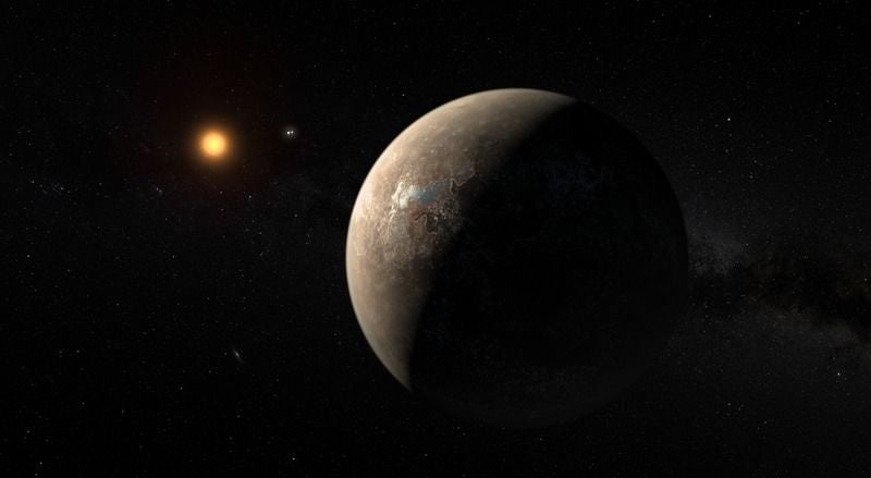
Artist’s rendering of the planet Proxima orbiting the red dwarf star Proxima Centauri. (Image: ESO/M. Kornmesser)
It’s been an exciting week for planet hunters with the discovery of the nearest exoplanet yet found, orbiting a star called Proxima Centauri. Now you can get a closer look at that star system via a live broadcast tonight, courtesy of therobotic telescope service Slooh. The fun starts at 8 PM ET/5 PM PT.
Proxima Centauri is a small red dwarf star located just 4.25 light years away, slightly closer to Earth than the famous binary pair of Alpha Centauri A and B. The newly discovered exoplanet has been dubbed Proxima b, and the ESO team pegs its mass as being roughly 1.3 times that of Earth.
According to Slooh team member Paul Cox, when collaboration launched its new telescopes in Chile back in 2007, Proxima Centauri was one of their first observational targets of its global network. Since getting a heads-up on the new exoplanet, the telescopes have been imaging the star every night.
“It’s amazing to watch that small red dot live in the online telescopes every night, and imagine the earth-like world that we now know orbits the star,” Cox said in a statement. “With the possibility that liquid water exists onProxima b, who knows, there may be some Centaurian amateur astronomers gazing back at us every night.”
You can share the wonder and watch the Live stream embedded below, or watch on the Slooh website. Broadcast host Eric Edelman will be joined by the University of Texas, Austin’s Michael Endl—part of the ESO team that discovered Proxima b—and Lisa Kaltnegger, director of Cornell University’s Carl Sagan Institute, who will address the implications of this discovery for extraterrestrial life.
https://youtu.be/lVQ7j-xHb6k

Σάββατο 27 Αυγούστου 2016

Ancient Poseidon mosaic found in Turkey’s Adana

ΕΝΑΝΤΙΑ ΣΤΗΝ ΤΟΥΡΚΙΚΗ ΠΡΟΚΛΗΤΙΚΟΤΗΤΑ ΝΕΑ ΜΩΣΑΙΚΑ ΠΑΡΟΥΣΙΑΖΟΝΤΑΙ ΣΤΟ ΦΩΣ ΤΗΣ ΔΗΜΟΣΙΟΤΗΤΟΣ!
ΑΣ ΕΛΠΙΣΟΥΜΕ ΟΤΙ ΤΟ ΔΙΠΛΩΜΑΤΙΚΟ ΣΩΜΑ ΚΑΝΕΙ ΚΑΛΑ ΤΗΝ ΔΟΥΛΕΙΑ ΤΟΥ.


Archaeological excavations in the southern Turkish province of Adana’s Yumurtalık district have unearthed a rare mosaic depicting the ancient Greek god of the sea, Poseidon. It is believed to date back to the 3rd or 4th century B.C.

The Poseidon mosaic was found in the frigidarium (large cold pool of a Roman bath) part of the ancient bath at the ancient city of Aegae, which is a 1st degree archaeological field. The bottom part of the mosaic contains partly ruined writing in Greek: “Greetings to all of you bathing.” 

Adana Provincial Culture and Tourism Director Sabri Tari said the coastal Yumurtalık district was called Aegae in the ancient era.

Tari said the city served as a naval base in the era of the Roman Empire and it was also a famous place for Asclepius, the god of medicine in ancient Greek religion and mythology. 

“One of three big Asclepius temples of the ancient world is in this city,” he added. 

Tari said the region is rich in historical tissue, and they had previously found a mosaic depicting the god of love, Eros. 

“We found a new mosaic during recent excavations. The Poseidon mosaic, which is a rare one in terms of its beauty, was unearthed in the grounds of the frigidarium,” he said. 

Mosaic nearly 11 square meters 

Adana Museum Deputy Director Nedim Dervişoğlu said they continued to place a big importance on excavations in order to further boost the province’s tourism potential, with such works carried out in a number of different parts of the city. 

“During excavations, we found a mosaic on a field over a space of 11.39 square meters. It is separated into two main panels. The depiction in the southeastern part of the mosaic has been completely destroyed while the depiction in the north shows Poseidon carrying a trident. There are dolphins in the right and left of Poseidon. When the excavations are completed around the mosaic, the depiction will be meaningful. We believe it dates back to the 3rd or 4th century B.C.,” Dervişoğlu said.


August/22/2016

Παρασκευή 26 Αυγούστου 2016

Why the earthquake in Italy was so destructive


The earth beneath Italy's Apennine Range — where amagnitude-6.2 earthquake struck early Wednesday — is a tangle of fault lines and fractured rock.
The mountains, which run the length of Italy like the zipper on a boot, were formed about 20 million years ago as the African plate plowed into Eurasia, crumpling crust like a carpet. Now things are moving in the opposite direction. The crust on the northern side of the range is pulling away from the south at a rate of three millimeters per year, causing the earth to shudder along the spider web of minor fault lines that run beneath the surface.
That, in part, explains why Italy is so earthquake-prone, and why Wednesday's temblor was so destructive. At least 241 people were killed and dozens injured. The town of Amatrice, near the epicenter, was almost entirely reduced to rubble. Thousands of people were left homeless.

Drone footage shows devastation of earthquake in central Italy

Play Video0:34
This footage was Tweeted out by a search and rescue firefighting squad from Rome. The mayor of one of the hardest hit towns, Amatrice, told state broadcaster RAI, “three quarters of the town is not there any more.” (TWP)
"Things are shifting around in complicated ways," said Susan Hough, a seismologist with the U.S. Geological Survey. "There's faults all along the Apennines that are fairly fragmented. They're capable of producing moderate and even large earthquakes, and it's kind of like throwing darts at a dart board — they just hit at different places over time."
Seven years ago, the target was L'Aquila, a city about 30 miles south of Amatrice. That earthquake killed more than 300. A century ago, it was Avezzano, where about 30,000 people died. Medieval Italians wrote of temblors that shook the mountain ranges and set church bells ringing as far away as Rome.
Earthquakes in this region are modest in magnitude — hundreds of 6.2 quakes happen around the world every year. Within hours of the Italian quake, a 6.8-magnitude temblor hit Burma. But that earthquake was much deeper, which means it was less destructive. According to Reuters, relatively few buildings collapsed, though three people were killed, including two children.
By contrast, quakes like those that hit L'Aquila and Amatrice were centered just below the surface.
"With deeper earthquakes, the waves have to travel farther, so we can have quite deep earthquakes that are not so damaging," Hough said. "But if it’s shallow, the energy released is quite close to the surface, so that’s an immediate punch."
Just as important as what the earth does, added seismologist Leonardo Seeber, is "what humans build on top of it."
Seeber, a research professor at the Lamont-Doherty Earth Observatory at Columbia University, was born in Florence and has studied the tectonic activity of the Apennine region for more than 35 years.
"Italy is an old country, and the houses are made of stone," he said. Closely packed medieval buildings, constructed before the emergence of things such as building codes and reinforced concrete, are vulnerable to shaking and much more dangerous when they collapse.
He compared the Italian temblor to the 2011 Virginia earthquake that shook the D.C. region exactly five years ago on Aug. 23. That quake measured a 5.8 on the Richter scale and was similarly shallow. But it happened in a more sparsely populated region, where most homes had resilient wooden frames. Not a single person died in that quake, and the property damage was relatively modest.
"It's tragic because these towns are like jewels," Seeber said of Amatrice and other hard-hit areas; they are centuries-old time capsules nestled in the mountains.
Their beauty is part of what makes them vulnerable. Italy got its gorgeous natural resources — craggy mountains, fertile soil, crystalline rivers — because of its tectonic activity. The collisions of plates and explosions of volcanoes account for some of what's best about Italy, Seeber said.
"As a seismologist, very often people ask me, 'I’m afraid of earthquakes, where should I go?'" he said. "And I tell them, 'You can go in the center of these plates, but you wouldn’t necessarily like it there."