Arctic sea ice cover appears to have reached its minimum extent on September 11, 2015. Sea ice extent on that day was measured at 4.41 million square kilometers (1.70 million square miles). It was the fourth lowest extent recorded since satellites began measuring sea ice in 1979.
Please note that the Arctic sea ice extent number is preliminary—changing winds could still push the ice extent lower. NSIDC will issue a formal announcement at the beginning of October with full analysis of the possible causes behind this year's ice conditions, particularly interesting aspects of the melt season, the set up going into the winter growth season ahead, and graphics comparing this year to the long-term record.
On September 11, Arctic sea ice reached its likely minimum extent for 2015. The minimum ice extent was the fourth lowest in the satellite record, and reinforces the long-term downward trend in Arctic ice extent. Sea ice extent will now begin its seasonal increase through autumn and winter. In the Antarctic, sea ice extent is average, a substantial contrast with recent years when Antarctic winter extents reached record high levels.
Please note that this is a preliminary announcement. Changing winds or late-season melt could still reduce the Arctic ice extent, as happened in 2005 and 2010. NSIDC scientists will release a full analysis of the Arctic melt season, and discuss the Antarctic winter sea ice growth, in early October.
Overview of conditions
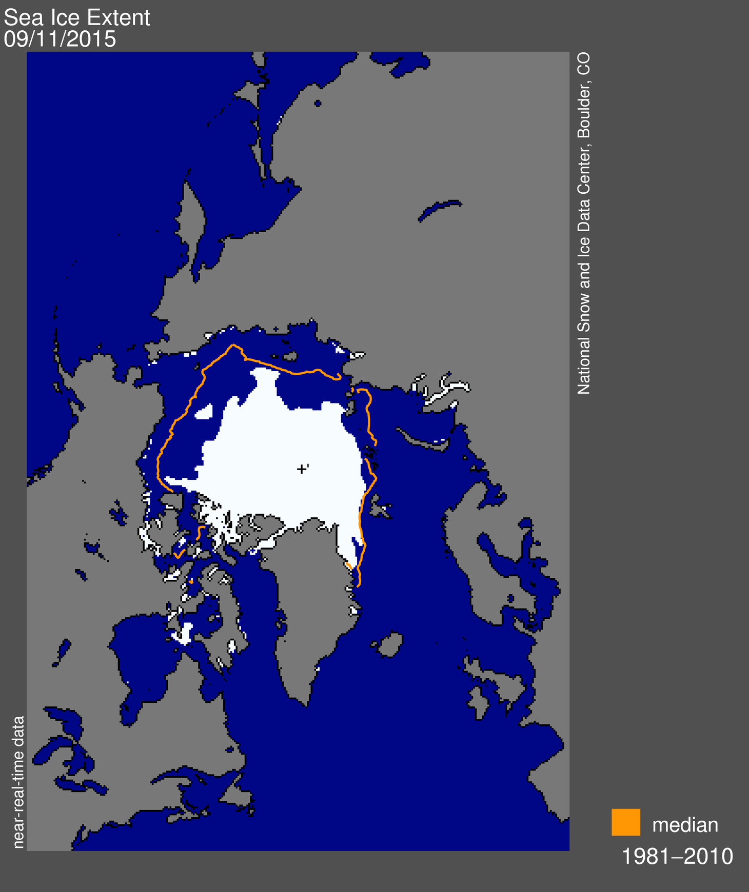
Figure 1. Arctic sea ice extent for September 11, 2015, was 4.41 million square kilometers (1.70 million square miles). The orange line shows the 1981 to 2010 average extent for the day. The black cross indicates the geographic North Pole. Sea Ice Index data.About the data
Credit: National Snow and Ice Data Center
High-resolution image
Credit: National Snow and Ice Data Center
High-resolution image
On September 11, 2015, sea ice extent dropped to 4.41 million square kilometers (1.70 million square miles), the fourth lowest minimum in the satellite record. This appears to be the lowest extent of the year. In response to the setting sun and falling temperatures, ice extent will now climb through autumn and winter. However, a shift in wind patterns or a period of late season melt could still push the ice extent lower.
The minimum extent was reached four days earlier than the 1981 to 2010 average minimum date of September 15. The extent ranked behind 2012 (lowest), 2007 (second lowest), and 2011 (third lowest). Moreover, the nine lowest extents in the satellite era have all occurred in the last nine years.
Both the Northern Sea Route, along the coast of Russia, and Roald Amundsen’s route through the Northwest Passage are open. How long they remain open depends on weather patterns and the amount of heat still present in the ocean mixed layer (about the top 50 feet of the ocean). The deeper and wider Northwest Passage route through Parry Channel, which consists of M’Clure Strait, Barrow Strait, and Lancaster Sound, still has some ice in it.
ΕΠΕΚΤΑΤΙΚΟΝ
Απολαύστε μια βαθιά βουτιά στην έρευνα η άνοδος της στάθμης της θάλασσας και οι επιστήμονες της NASA και τους συναδέλφους τους να συζητήσουν την έρευνά τους πάνω και γύρω από το κάλυμμα πάγου της Γροιλανδίας.
ΕΠΕΚΤΑΤΙΚΟΝ
Απολαύστε μια βαθιά βουτιά στην έρευνα η άνοδος της στάθμης της θάλασσας και οι επιστήμονες της NASA και τους συναδέλφους τους να συζητήσουν την έρευνά τους πάνω και γύρω από το κάλυμμα πάγου της Γροιλανδίας.
Δεν υπάρχουν σχόλια:
Δημοσίευση σχολίου
NO COMMENTS!