BIG BANG NEWS
RESEARCH, TECHNOLOGY, SCIENCE, DIACHRONIC NEWS, COMMENTS, ,SPORTS,MUSIC,SKY AND STARS,AND MUSH MORE.

Αναζήτηση αυτού του ιστολογίου

Πέμπτη 5 Ιουνίου 2014

Google Glass gun app would provide 'mind-blowing' ability to shoot around corners

Google Glass gun app would provide 'mind-blowing' ability to shoot around corners

Published time: June 04, 2014 23:48
Screenshot from YouTube user trackingpoint

Tracking Point, a Texas company that develops precision-tracking technology for firearms, announced via a YouTube video on Thursday that it has combined wearable technology, like Google Glass, with a Precision Guided Firearm (PGF) in a way that allows users to shoot around corners. The new combined system is called ShotView.
A new Google Glass application would allow shooters to aim around corners while protecting them from return fire, the app developer claims.
“When paired with wearable technology, PGFs can provide unprecedented benefits to shooters, such as the ability to shoot around corners, from behind low walls, and from other positions that provide exceptional cover,” the company said in the video description. “Without PGF technology, such positions would be extremely difficult, if not impossible, to fire from.”
Vice’s Motherboard website compared the new technology with a jet’s heads-up display (HUD), a transparent display that allows pilots to read data without looking away from their normal view.“Much like a jet fighter's head's up display (HUD), TrackingPoint's wearable PGF app gives users the visual aids needed to take their aiming and shooting chops to previously impossible levels.”
Oren Schauble, Tracking Point’s director of marketing, told Motherboard in April, "Being able to shoot around corners and over hills is a little mind-blowing when you actually do it. Things keep on rolling."
The ShotView app works by streaming video from the tracking scope’s HUD to WiFi devices. “This enables direct device streaming for phones, tablets and many wearables. For additional networking, phones can connect via bluetooth and the Internet to share the apps data with additional devices,”the promotional video claims. Combining the PGF with Google Glass “allows for accurate shots around corners, from supported positions, behind-the-back, to the side and over barricades.”
The application is not available for the public yet, and a rep from the company told Huffington Post there are no plans to make the app available to consumers. Glass integration is still in the testing phase, Time reported.
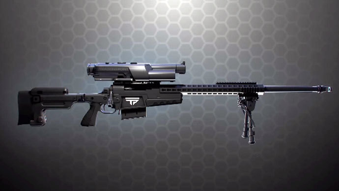
The company began selling its (non-ShotView) PGFs to consumers in 2013. These rifles use a tracking scope and a guided trigger to allow users to reliably hit targets from 1,000 yards, according to their website. Their products have a variety of calibers, barrel lengths, chassis systems, applications and ammunitions.
Tracking Point already provides the US military with six of its so-called “smart” rifles, which come equipped with an internal computer system as well as sensors that gauge environmental factors to help a soldier aim. Google Glass is no stranger to the military, either, as a US Air Force research team is in the process of beta-testing Google Glass headsets for possible utilization in battlefield scenarios.

US Army testing precision guided ‘smart’ rifles - report

Published time: January 17, 2014 23:21
Screenshot from YouTube user trackingpoint

Tracking Point has announced that the military has purchased six of its so-called “smart” rifles, which are priced at between $10,000 and $27,000 each. That’s a hefty fee compared to the hundreds of dollars the Army pays to fit soldiers with the usual M-16 A2 rifle or M-4 Carbine, but the Tracking Point model reportedly comes fitted with aiming technology so advanced that the military may hope a $10,000 investment will help save money on ammunition.
The US military is investing in an advanced firearm that comes equipped with an internal computer system as well as sensors that gauge environmental factors to help a soldier aim, according to a technology startup known as Tracking Point.
A shooter using a smart sniper rifle would merely need to tag a target viewable on a screen that’s visible when they are looking through the gun’s scope. The internal computer system will then tell the shooter exactly how to hold the gun and when to press the trigger.
Tracking Point displayed the weapon at the annual SHOT show weapons convention in Las Vegas, Nevada, earlier this month. DefenseTech.com reported that US Army officials bought six of the precision-guided firearms.
Rifles can communicate with each other,” said Oren Schauble, a company marketing official. “We can enable a more information-driven combat in the sense that you can tag targets. You can pass off those targets to someone else with a scope. There’s a whole layer of communication that comes with having a rifle that can designate and track targets.”
Part of the motivation behind developing the precision-guided rifle, the company said, is that battlefields are becoming increasingly complex and, more importantly, connected. A Linux-powered computer in the gun scope collects ballistic data, battlefield images, and records atmospheric conditions such as cant, inclination, and even the tilt of the earth at that precise moment.
Schauble said the company has sold approximately 500 guns to a clientele that includes wealthy collectors and safari hunters.
The guns are also wireless, which means the footage and information can be live-streamed to a smart phone, tablet, or laptop.
The only way to guarantee accuracy is to control all the variables,” Scott Calvin, a Tracking Point representative, told Defense Tech. The only major factor that the gun cannot track is wind speed, which must be entered manually, Calvin added.
As with any new product that has its proponents, there are skeptics who assert that the technology has gone too far by eliminating the need for patience and calm in a high-pressure situation.
It’s the traditional shooting fish in a barrel or the sitting duck,” hunter Chris Wilbratte told NPR. “I mean, there’s no skill in it, right? It’s just you point, you let the weapon system do its thing and you pull the trigger and now you’ve killed a deer. There’s no skill.”
West Point military academy graduate and Vietnam War veteran Chris Frandsen said the Tracking Point gun should be prohibited in the civilian world because a criminal could use it and potentially remain undetected from a faraway distance.
Where we have mental health issues, where we have children that are disassociated from society early on, when we have terrorists who have political cards to play, we have to restrict weapons that make them more efficient in terrorizing the population,” he said.

Τετάρτη 4 Ιουνίου 2014

Residents Hope to Commemorate Children after Mass Grave Find

Δημοσιεύτηκε στις 4 Ιουν 2014
Residents campaign for babies discovered in mass Irish grave to receive commemoration.

Full Story:

Local residents on Tuesday said they hoped a campaign is making headway to commemorate the unmarked mass grave of nearly 800 babies found in Tuam, County Galway, Ireland.

The burial site was discovered under concrete in 1975 by friends Barry Sweeney and Francis Hopkins when they were playing as children.

"It was just a concrete slab, it was cracked. Myself and Francis were in here and we pulled it open, cracked it open, and there it was - skulls piled up on top of each other. Maybe eight or nine feet deep piled up. So, we just being kids at the age we were, we just ran," Sweeney said.

"And at the time we didn't realise the magnitude of what was going on - we were kids," Hopkins added.

The infants were buried without coffins in the grounds of a former Bons Secours home for unmarried mothers between 1925 and 1961.

Local historian Catherine Corless said that before the discovery, there was nothing marking the buried remains.

"This is actually a whole mass grave and they are all buried around here in this area, and no little cross, no marking, no headstone. Nobody knows who they are or what they are," she said.

A total of 796 babies toddlers and children were buried in this mass grave. Death records show the children died from malnutrition and infectious disease.

A representative from the Catholic Archdiocese of Tuam, Father Fintan Monaghan, said that it was inappropriate to judge the past from today's standards.

"I suppose we can't really judge the, I suppose, the past from our point of view, or from our lens but all we can do is to mark it appropriately and to make sure there is a suitable place here where people can come and can remember the babies that died here," he said.

The Fundraising Committee plans to engrave in stone all 796 names of the children found buried here.

"These children have nothing over them and we're not prepared to stand here as women and let them happen," local resident Teresa Killeen Kelly said.

Irish broadcaster RTE says that a small financial donation has also now been made by the Bons Secours Sisters to help the community build a memorial.


Lugansk Airstrike: Footage of Kiev's planes behind deadly bombings


Asteroid To Fly-By Earth Could Be Half-Mile Wide | Orbit Animation

Asteroid 2014 HQ124 was discovered on April 23rd, 2014 and its closest approach (~3 Lunar distances) will occur June 8th. Current estimates show it to be between .25 miles - .56 miles wide, and traveling at 31,000 mph.

Δευτέρα 2 Ιουνίου 2014

Erzbergrodeo 2014: Watch it On Demand


http://www.redbull.com/en/motorsports/offroad/videos/1331654498064/erzbergrodeo-2014-red-bull-hare-scramble-watch-it-live


1 mountain. 500 riders. 15 checkpoints. 4 hours of time. And only a handful of riders crosses the finish line!

Welcome to the cruel reality of Erzbergrodeos true highlight - the RED BULL HARE SCRAMBLE, which is regarded the toughestst dirt bike race of the world! Only the fastest 500 riders of the Iron Road Prologue qualify for the technically most demanding offroad competition worldwide.

The starting ceremony already is a legend in its very own right. When, at 11:00 am, Karl Katoch guides the competitors to the Erzberg lake, the thrilling atmosphere causes gooseflesh again. At 12:00 o’ clock straight, waves of 50 riders are set loose and places in the front rows are much sought-after. Starting positions correspond with the times reached in the prologue, so the fastest 50 riders of Iron Road Prologue start in the first row of the RED BULL HARE SCRAMBLE.

When Heinz Kinigadner and Karl Katoch rise the starting flag, it’s 4 hours time for the riders to pass 20 checkpoints on the 23 kilometer track. At 4:00 pm, the game is over as the chequered flag is swung for the very last time. All riders still fighting with the track at this time are listed in the official results with their last checkpoint passed in running order. Right after the start it is clear to everyone that there will be only one way to the finish line - straight up the mountain! While the top-riders are served with a spicy potpourri of endless uphills, formidable downhills, narrow forest trails and unforgiving rock passages, the vast majority of riders will spend most of their four hours at one of the first uphill sections. Only the best of the best are able to reach the legendary Red Bull Arch inside the Erzberg-Arena, making them the elite enduro riders in the whole world.

The prize for this inhuman drudgery is no prize money. It‘s a piece of rock, shaped directly out of the Iron Giant‘s side. A piece of rock from the mountain the riders have beaten with willpower, determination and quite some battle scars...


The 20th Red Bull Hare Scramble in photos
By Tom Bellingham on 2 June 2014 in Enduro


The best images from the 20th edition of the Red Bull Hare Scramble won by Jonny Walker.


XX – Erzberg's 20th anniversary

XX – Erzberg's 20th anniversary

This year marked a special anniversary for Erzberg, the 20th year of the Red Bull Hare Scramble. Competitors lined up in an 'XX' formation at the start line ahead of the event.© Philip Platzer/Red Bull Content Pool


GoogleJonny Walker was on fine form

Jonny Walker was on fine form

Jonny Walker was on form all weekend. The Brit finished sixth in the Iron Prologue, putting himself on the front row for the all-important Red Bull Hare Scramble.© Philip Platzer/Red Bull Content Pool


GoogleA tribute to Kurt Caselli

A tribute to Kurt Caselli

A rider pays tribute to the late Kurt Caselli, whose life was tragically cut short when he died during an accident at the Baja 1000 in November 2013.© Jonty Edmunds


GoogleThe toughest race

The toughest race

There's a reason people call the Red Bull Hare Scramble the toughest race in the world and the competitors found out why... the hard way.© Philip Platzer/Red Bull Content Pool


GoogleThe 20th Red Bull Hare Scramble is GO!

The 20th Red Bull Hare Scramble is GO!

1,800 competitors were whittled down to just 500 for the Red Bull Hare Scramble. Thankfully for the riders, the conditions were a lot drier than last year's event.© Philip Platzer/Red Bull Content Pool


GoogleFightback from Jarvis

Fightback from Jarvis

It was a difficult start for the reigning Red Bull Hare Scramble champion, Graham Jarvis. But he soon fought back, and a sensational comeback put him into second at the flag.© Jonty Edmunds


GoogleA dominant display from Walker

A dominant display from Walker

Jonny Walker was in a league of his own, riding the race of his life out front. No one came close to stopping Walker from winning his second Red Bull Hare Scramble.© Philipp Schuster/Red Bull Content Pool


GoogleFor some, it's the taking part that counts

For some, it's the taking part that counts

While the frontrunners go for the biggest prize in Hard Enduro, some are pleased just to see the chequered flag... and who can blame them!© Jonty Edmunds


GoogleLettenbichler and Bolton climb the hill

Lettenbichler and Bolton climb the hill

Both Andreas Lettenbichler and Paul Bolton had impressive results. Lettenbichler joined his KTM team-mate Jonny Walker on the podium in third and Bolton finished as the best of the privateers in fifth.© Jonty Edmunds


GoogleErzberg victory number two for Walker

Erzberg victory number two for Walker

Jonny Walker scored his second win at Erzberg, dominating the Red Bull Hare Scramble and winning by a huge 13 minutes.

Mitsubishi XR-PHEV Evolution Vision Gran Turismo (GT 6, 2014)


Ένα πρωτότυπο Evolution από τη Mitsubishi

Το αυτοκίνητο διαθέτει plug-in hybrid EV τεχνολογία

Με αφορμή το Gran Turismo, η Mitsubishi παρουσίασε την Evolution εκδοχή του πρωτότυπου crossover XR-PHEV, το οποίο κάνει χρήση υβριδικής plug-in τεχνολογίας. Πρόγευση από το Evo του μέλλοντος; Θα δείξει…

Ακολουθώντας τα βήματα του XR-PHEV concept, το XR-PHEV Evolution είναι ένα μοντέλο υψηλών επιδόσεων, το οποίο διαθέτει ένα αμάξωμα από μείγμα ανθρακονημμάτων και ενισχυμένου πλαστικού, ενώ στην πίσω όψη του κυριαρχεί η τεράστια αεροτομή. Άκρως επιθετική είναι και η εμπρόσθια όψη του οχήματος, ενώ το concept της Mitsubishi διαθέτει αεροδυναμικά πλευρικά μαρσπιέ και ζάντες αλουμινίου 20 ιντσών.

Φειδωλή ήταν η Mitsubishi σχετικά με τα τεχνικά χαρακτηριστικά του XR-PHEV Evolution. Ωστόσο, το αυτοκίνητο διαθέτει plug-in hybrid EV τεχνολογία, ενώ φέρει και ένα αυτόματο κιβώτιο διπλού συμπλέκτη 8 σχέσεων (DCT), το οποίο στέλνει την κίνηση και στους 4 τροχούς.

Το Concept XR-PHEV Evolution Vision Gran Turismo είναι διαθέσιμο μόνο στο video game Gran Turismo 6. Μπορεί να αποκτηθεί είτε συμπληρώνοντας έναν γύρο στο νέο Seasonal Event, είτε απευθείας μέσω του τμήματος «Cars» του παιχνιδιού.

Το θέμα, όμως, μοιάζει να είναι μεγαλύτερο από ένα video game, καθώς το εν λόγω πρωτότυπο αποκαλείται η Evolution εκδοχή του περσινού πρωτότυπου σπορ SUV XR-PHEV της ιαπωνικής φίρμας. Αν αυτό συνδυαστεί με παλαιότερα δημοσιεύματα που κάνουν λόγο πως ο διάδοχος του Lancer Evolution μπορεί να είναι ένα υβριδικό crossover επιδόσεων, μπορεί να κοιτάμε μια πρώτη εκδοχή του μοντέλου που θα αναλάβει το ρόλο του Evo στη μελλοντική γκάμα της Mitsubishi. Μια σχετική είδηση της τελευταίας στιγμής, έρχεται από το αμερικάνικο κομμάτι της Mitsubishi και αναφέρει πως το Lancer Evolution θα «επιβιώσει» και το 2015.


Κυριακή 1 Ιουνίου 2014

Photographer goes to great heights for call to arms on sprawl


Photographer goes to great heights for call to arms on sprawl
BY VICTORIA FLEISCHER May 30, 2014 at 2:58 PM EDT


SKYE ISLE II Florida. Photo by Christoph Gielen courtesy of Jovis Verlag, Berlin 2013

Christoph Gielen’s large-scale aerial images of urban planning are his means of participating in a conversation about sustainable development. He sees his collection of photographs, titled “Ciphers,” as a code of human habitation — one that needs to be deciphered.

“At first glance, they may really appear as something that they are not, something organic or even as proliferating cell growth seen under a microscope,” said Gielen.

Gielen is not an architect and he can’t speak to the future of development, but he hopes his photographs will serve as a tool for those who can make a difference. And if he drums up interest by compelling viewers to pay attention to land use, he will consider his work a success.

Art Beat recently spoke to Christoph Gielen about “Ciphers.” The transcript below was lightly edited for length.

ART BEAT: How did this project come about?

CHRISTOPH GIELEN: The initial idea behind the project was to really make a case for sustainable planning but from an artist’s perspective. I want to reach out to anyone interested in society’s role in land use and the effects on the environment. That was the initial idea behind it and my goal with Ciphers was really to examine the broader ramifications of building trends well beyond American borders, to really bring about an understanding of growth machines that systematically develop car dependency and more car dependent low-density organization. If photography can be used as a call to action, I like utilizing my photography as a primary medium for that. Then I invite land use experts to comment on and to solve.


STERLING RIDGE II Florida. Photo by Christoph Gielen courtesy of Jovis Verlag, Berlin 2013

ART BEAT: Can you explain what we’re seeing in the photos?

CHRISTOPH GIELEN: We’re all familiar with sprawl and the inherent problems of sprawl and it’s really quite a drab subject so what I wanted to do is utilize photography to make it compelling. I chose settlement patterns that were particularly striking. What we’re looking at is housing formations that I found that were compelling enough for people to pay attention to. They are symbolic of poor land use, if you will. So after a lengthy research period I came up with those particular locations and ended up photographing them.


CONVERSIONS VII Urban California. Photo by Christoph Gielen courtesy of Jovis Verlag, Berlin 2013

ART BEAT: What was the process like to get these images? What were you looking for in the research?

CHRISTOPH GIELEN: The photographing itself is actually the smallest part of it all. In the research part, I would look at variables that are relevant to land use, so one big determining factor for me was foreclosure rates, so that was probably one of the biggest factors and I saw that they, as a phenomenon, really directly tie to rates of housing development. I found that foreclosure hotspots for instance occur in places with the least location efficiency. Foreclosure statistics are publicly available by state and by county; they all list them at companies like RealtyTrac. Other statistics would have been settlement rates, I was looking at some of the fastest developing regions and then I would target in on specific regions and travel there.

I would use a car and I would just travel to all these destinations and examine these locations from the ground and see how stricken are these regions and what do they look like and I would oftentimes pose as a prospective homebuyer and go around with a realtor for instance and have them explain how these neighborhoods see themselves and what the selling points would be.


UNTITLED VIII Arizona. Photo by Christoph Gielen courtesy of Jovis Verlag, Berlin 2013

Then I would work with mapping services from the U.S. Geological Survey — I found them to be a fantastic partner, they really make all these maps available publicly. I would look at current maps and look for compelling clusters and once I found those I would go with a satellite search often times and see what does it look like from great height.

At the very end I would then sometimes be able to get in touch with the folks who actually planned and designed those neighborhoods and to find out what’s the background story, what were the priorities. In all cases, they would have nothing to do with today’s standards of sustainability.

And then I would go up at the very end with a helicopter and photograph very specifically. We would perform these vertical spiral movements to get it from different altitudes until I felt like I had what I wanted to get, how I wanted to show those.


UNTITLED XI Arizona. Photo by Christoph Gielen courtesy of Jovis Verlag, Berlin 2013

ART BEAT: What did you find out when you spoke to the people who planned the neighborhoods you were photographing?

CHRISTOPH GIELEN: Some of the most startling news I found was from a region that was growing very fast south of Las Vegas. There is a region that is called the Black Mountains and until the real estate crash that was really some of the fastest growing in the U.S. What the developers did there was almost as if with zip code marketing, they would come up with buyer profiles and look at statistics such as age group, gender, family, but also, aside from income structure, they would look at shopping preferences, so you would end up with a very targeted development for a very specific group of prospective homebuyers. You would end up with a neighborhood that is completely homogeneous, so not only do you end up with people that are the same race, the same income, but even that have the same preferences as consumers. Not only does each house look the same, but the people actually have the same preferences that live there, so that was a little bit spooky.


UNTITLED X Nevada. Photo by Christoph Gielen courtesy of Jovis Verlag, Berlin 2013

Then on the other hand, which was great, was the Department of Transportation, for instance, in California, they made some of their original maps, blueprints, plans available of some of these major interchanges because it is part of the public record. So I was able to look at how they pieced it together. What is interesting to me from a sustainability perspective is seeing that there’s no consideration whatsoever in terms of land wasted. One interchange that made it into the book that I’m quite fond of that looks quite abstract in San Bernardino County and it looks huge. You would never know it from the ground, but it’s absolutely gigantic and it wastes so much land just simply to connect two highways in the middle of nowhere. The consideration of the land itself isn’t anywhere in these plans.

What I’m really after is that some of these circular plane communities may well be somehow an intrinsic expression of human culture, but maybe the challenge of today, with overpopulation, requires a new set of settlement patterns.


UNTITLED III Arizona. Photo by Christoph Gielen courtesy of Jovis Verlag, Berlin 2013


UNTITLED Nevada. Photo by Christoph Gielen courtesy of Jovis Verlag, Berlin 2013


DEER CREST II Suburban California. DEER CREST II Suburban California


CONVERSIONS Suburban California. Photo by Christoph Gielen courtesy of Jovis Verlag, Berlin 2013


UNTITLED VI Nevada. Photo by Christoph Gielen courtesy of Jovis Verlag,
Berlin 2013

An Old Bird on the Greenland Ice

An Old Bird on the Greenland Ice
acquired May 1, 2014download large image (8 MB, JPEG, 5760x3840)
Flying over the polar regions can be both awesome and tedious, beautiful and boring. It's a frontier that few eyes have seen, but the utter whiteness of the snow and ice can start to blend into a sameness that becomes disorienting. Landmarks become welcome signs, even when that landmark is a somber reminder of flights gone wrong.
The image above shows the Kee Bird, a wrecked B-29 Superfortress that made an emergency landing on a northwest Greenland ice sheet in 1947. The image was acquired on May 1, 2014, by the Digital Mapping System (DMS), an instrument attached to NASA’s P-3 Orion airplane for the Operation IceBridge campaign.
The Kee Bird was a U.S. Air Force plane that made a crash landing after running into foul weather and other issues during a reconnaissance flight to the North Pole. The entire crew survived the crash, but then had to wait for more than three days to be found and rescued. In the 1990s, a private group of airplane and history aficionados attempted to restore and fly the plane, only to have it catch fire in the process. The wreck still lays on the ice sheet and is slowly being covered by wind-blown snow and ice.
Since 2009, Operation IceBridge has made annual campaigns to the Arctic and Antarctic to monitor glaciers, ice sheets, and sea ice. The 2014 northern spring campaign ended on May 23 after eleven weeks of flights.
“The plane wreck lies right in between two of major science targets—Humboldt and Petermann Glaciers—and because of that we fly almost directly over it nearly every year,” said John Sonntag, a researcher from NASA’s Wallops Flight Facility who has collected Kee Bird photos since the early 1990s. “When you spend eight hours a day, five days a week staring at a blinding white ice sheet, something interesting to look at comes as a rather welcome sight.”
acquired April 20, 2013
Michael Studinger, the NASA scientist who leads IceBridge, shot the second photo in the spring of 2013. In the oblique view, you can see the shadow of the P-3 research plane. Faint thin lines across the ice are likely polar bear tracks.
NASA photographs courtesy of IceBridge Digital Mapping System (top) and Michael Studinger, NASA GSFC (lower). Caption by Mike Carlowicz.
Instrument(s): 
Aircraft Sensors - DMS

5/18/14 Wright to Newcastle, WY Supercell Time-Lapse

alma4anttimelapse2

MOTO GP MUGELLO ITALIA


Marquez comes out on top in duel with Lorenzo

Mugello MotoGP Race Marquez
Sunday, 1 June 2014

An intriguing duel between Marc Marquez (Repsol Honda Team) and Jorge Lorenzo (Movistar Yamaha MotoGP) saw the former come out on top at Mugello, with Valentino Rossi (Movistar Yamaha MotoGP) joining them on the podium.

The two Spaniards put on a great show in front of the Italian crowd, battling for the lead for several laps, only for Marquez to clinch a sixth successive victory in 2014 by 0.121s on the final lap.
At his 300th Grand Prix the yellow sea of fans were willing Rossi to capitalise on any mistake from the front two, and although The Doctor had to settle for third by just under three seconds it was still a great ride for him from 10th on the grid.
With Dani Pedrosa (Repsol Honda Team) and impressive rookie Pol Espargaro (Monster Yamaha Tech3) the next two across the line – albeit more than 10 seconds further back – there were four Spaniards in the top five.
Behind them Italians Andrea Dovizioso (Ducati Team) and Andrea Iannone (Pramac Racing) also got great support from the crowd en route to sixth and seventh respectively, with Iannone making a brilliant start and leading in the early stages having started second on the grid.
The top ten was completed by Alvaro Bautista (GO&FUN Honda Gresini),Aleix Espargaro (NGM Forward Racing) and Yonny Hernandez (Energy T.I. Pramac Racing).
Hector Barbera (Avintia Racing) and Michel Fabrizio (Octo IodaRacing Team) both retired from the race with technical problems.
Bradley Smith (Monster Yamaha Tech3) crashed out on lap 4, but walked away unharmed. Shortly afterwards Cal Crutchlow (Ducati Team) and Stefan Bradl (LCR Honda MotoGP) went down, the German hitting the Englishman's bike as it slid across the track, with both riders fortunately avoided injury.