BIG BANG NEWS
RESEARCH, TECHNOLOGY, SCIENCE, DIACHRONIC NEWS, COMMENTS, ,SPORTS,MUSIC,SKY AND STARS,AND MUSH MORE.

Αναζήτηση αυτού του ιστολογίου

Τετάρτη 15 Ιουνίου 2016

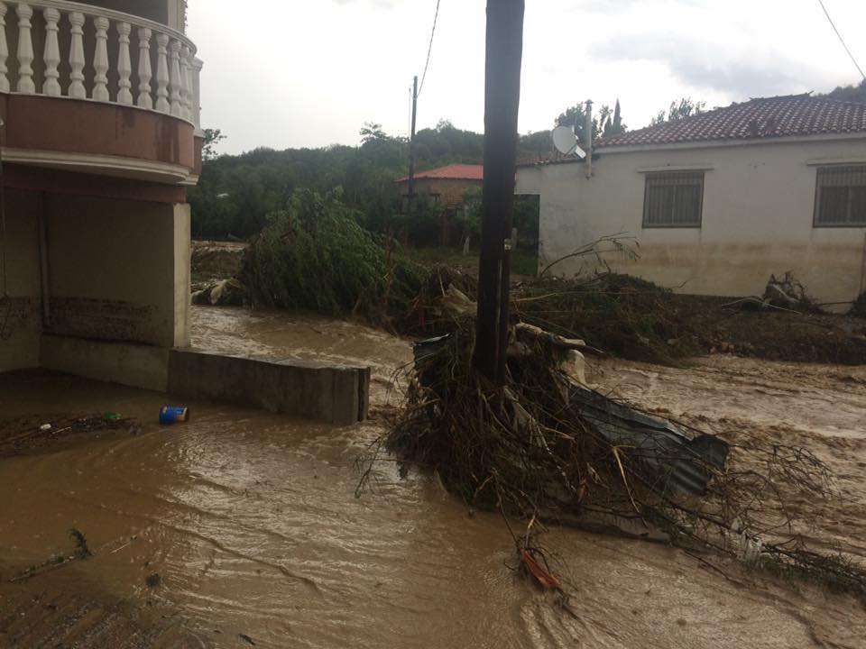
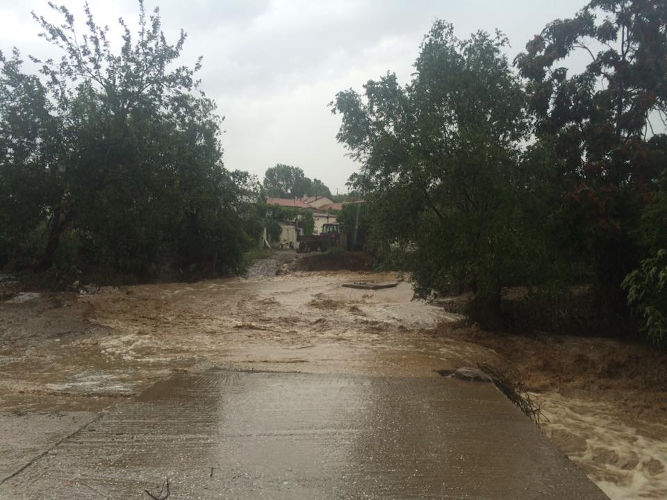
Ανεμοστρόβιλος κατηγορίας EF-1 χτύπησε τη Γενισέα Ξάνθης – Εικόνες βιβλικής καταστροφής ! 06-15-2016 01:00 / 235 προβολές Ανεμοστρόβιλος κατηγορίας EF-1 χτύπησε τη Γενισέα Ξάνθης – Εικόνες βιβλικής καταστροφής ! Έντονα καιρικά φαινόμενα έπληξαν την Τρίτη την Ξάνθη, όπως και ευρύτερα την Θράκη

Έντονα καιρικά φαινόμενα έπληξαν την Τρίτη την Ξάνθη, όπως και ευρύτερα την Θράκη, με την βροχόπτωση να κάνει αισθητή την παρουσία της ανά τακτά χρονικά διαστήματα ενώ στην Ξάνθη έκανε την εμφάνισή του και ανεμοστρόβιλος

Όσο εντυπωσιακός ήταν ο νέος ανεμοστρόβιλος που χτύπησε αυτή τη φορά την Ξάνθη, άλλο τόσο καταστροφικός ήταν. Νωρίς το απόγευμα της Τρίτης μάλιστα στην πεδινή περιοχή του Νομού έκανε την εμφάνισή του ένας αρκετά μεγάλος ανεμοστρόβιλος ενώ στην περιοχή επικρατούσε κακοκαιρία, με τους κεραυνούς και τις αστραπές να εναλλάσσονται στην ατμόσφαιρα. 
Ξερίζωσε τα κυπαρίσσια και κατέστρεψε σχεδόν όλους τους τάφους !
H μεγαλύτερη καταστροφή σημειώθηκε στα Νεκροταφεία του χωριού. Εκεί ο ανεμοστρόβιλος ξήλωσε όλα τα ογκώδη κυπαρίσσια και κατέστρεψε πάνω από το 70% των τάφων. Οι εικόνες είναι πράγματι απίστευτες από την εικόνα που αντίκρισαν οι κάτοικοι μετά την μπόρα !
Όπως ανέφερε ο Δήμαρχος Γιώργος Τσιτιρίδης, η καταστροφή είναι πολύ μεγάλη ενώ κάποιες οικογένειες έχουν κυριολεκτικά καταστραφεί. Άμεσα ενημερώθηκε ο Περιφερειάρχης, ο Αντιπεριφερειάρχης και η Πολιτική Προστασία, για τις μεγάλες ζημιές που έχουν σημειωθεί ενώ από την επομένη αναμένεται να ξεκινήσει η καταγραφή τους.


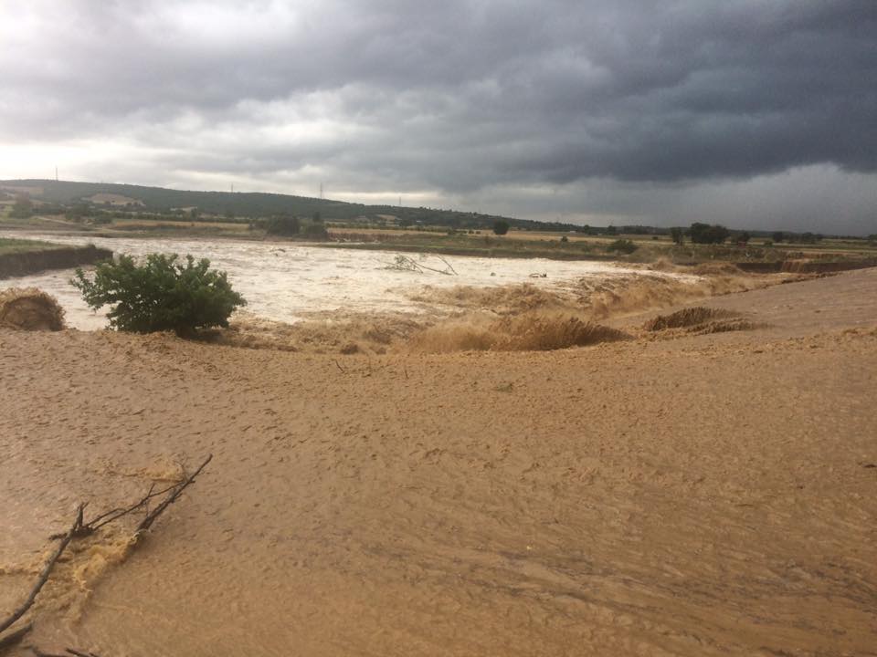
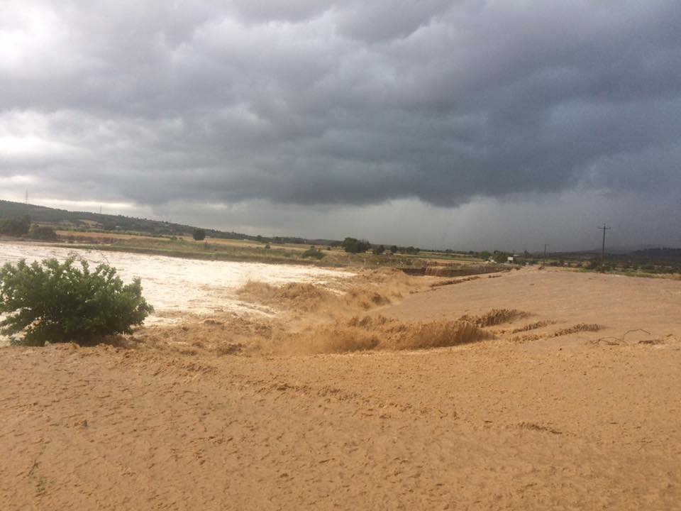
Αρκετές είναι οι καταστροφές που προκαλεσε στη Ροδόπη, η μεγάλη νεροποντή της Τρίτης.
Κυρίως κτηνοτροφικές μονάδες αλλά και οικισμοί, όπως ο Δοκός στο Δήμο Αρριανών επλήγησαν από την κακοκαιρία ενώ η ορμή του νερού ήταν πρωτόγνωρη και αρκετά επικίνδυνη.
13428542_10153693767901453_4118072052206980054_n13417473_10153693767801453_4204329297679281343_n13466096_10153693767726453_5068006779015772720_n13432401_10153693767661453_4686534570827112469_n13413052_10153693655741453_8437449839730187675_n13413159_10153693727766453_3562692389412139297_n13465950_10153693655691453_4325090469839978808_n


Τρίτη 14 Ιουνίου 2016

Συναντηση του υπουργου εξ. της Κυπρου κ. Κασουλιδη με τον υπουργο εξ. Kerry usa στην Ουασιγκτον.

ΣΙΓΗ ΙΧΘΥΟΣ ΩΣ ΤΟ ΤΙ ΛΕΧΤΗΚΕ ΣΤΗΝ ΣΥΝΑΝΤΗΣΗ!


U.S. Secretary of State John Kerry and Cypriot Foreign Minister Ioannis Kasoulidis address reporters before their bilateral meeting at the U.S. Department of State in Washington, D.C., on June 13, 2016


U.S. Secretary of State John Kerry welcomes Cypriot Foreign Minister Ioannis Kasoulidis to the U.S. Department of State in Washington, D.C., for their bilateral meeting on June 13, 2016

Κυριακή 12 Ιουνίου 2016

ESA astronaut Tim Peake set out to discover if he could make himself dizzy on board the International Space Station

Δημοσιεύτηκε στις 12 Ιουν 2016
ESA astronaut Tim Peake set out to discover if he could make himself dizzy on board the International Space Station. His NASA crewmate Tim Kopra lent a hand to put Tim in a spin.

When astronauts first arrive in space, they usually feel pretty rough for about the first 24 hours. They report feeling dizzy, disorientated and sometimes nauseous. This has to do with the vestibular system. In microgravity the fluid in the inner ear is floating and so the brain is getting mixed signals compared to what the eyes are seeing. After about 24 to 48 hours, the brain starts relying more on information that is coming from the eyes. Once this happens, in theory, their brain is better able to cope with all kinds of different orientations and of course spinning...
</div>

''ΜΠΑΧΑΛΟ'' ΤΗΝ ΕΚΑΝΑΝ ΟΙ ΧΟΥΛΙΓΚΑΝΣ ΤΗΝ ΜΑRΣΕΙΓ VIDEO


Δημοσιεύτηκε στις 11 Ιουν 2016
A l'approche du match à hauts risques au Vélodrome de Marseille entre l'Angleterre et la Russie (ce soir 21h), les violences se succèdent dans la ville entre supporteurs et forces de l'ordre. Un nouveau seuil a été franchi dans la violence cet après-midi, avec une série de heurts entre supporters des deux camps et contre les forces de l'ordre. Vers 19h30, les marins-pompiers avaient dénombré 13 blessés dans le centre-ville. Un supporteur anglais se trouve entre la vie et la mort. Un reportage pour le JT de France 2.


An England fan caught up in clashes at the end of the Three Lions' game against Russia has told Sky News he thinks there is "definitely going to be a repeat" of the violence.
England supporters were forced to flee from the Stade Velodrome in Marseille shortly after the end of the Euro 2016 match as Balaclava-clad thugs broke through a line of stewards.
Mark Leader, who was inside the French stadium on Saturday night, told Sky News Russian supporters started "smacking everyone they could".
He said: "We had to run, jump down seats, (we) jumped over a fence, people (were) jumping 10ft just landing on their heads and their backs just trying to get away. People just had to run.
"It was pretty frightening. If you didn't get away, you got hit, it was pretty simple. So people just ran."
Mr Leader said he was certain the violence was planned, and added he thinks there will be further clashes next week.
England play Wales in Lens on Thursday - the day after Russia play Slovakia in nearby Lille, which is around 25 miles away.
"There's definitely going to be a repeat," Mr Leader told Sky's Siobhan Robbins.
"The police don't really do anything until it all goes off anyway.
"If Russia are there, if England are there …The French fans are just as bad as well, it's definitely going to go off."
The ugly scenes inside the stadium were the climax to three days of disorder in the Mediterranean port city that has left at least one Briton seriously injured and as many as another 20 fans hurt.
Fist fights and bottle throwing between rival supporters caused scenes of mayhem in the run-up to England's opening match of the tournament, with the FA calling on French police to deal with perpetrators swiftly.
The Football Association has condemned the "terrible" conduct of drunken English fans who were involved.
Speaking at a post-match conference, FA spokesman Mark Whittle said the day's events were regrettable.
"The FA is very disappointed about the terrible scenes of disorder and of course condemns such behaviour," he said.
"It is now in the hands of the relevant authorities to identify those involved in trouble and deal with them appropriately and quickly.
"At this time the FA urges England supporters to act in a respectful manner and support England in the right way."
00:05/01:58
Meanwhile, there have also been reports of violence in Nice, where riot police were called to disperse local fans who began to attack Northern Irish supporters ahead of their game against Poland later.
Gary McAllister, chairman of the Northern Ireland supporters' clubs, wrote on Twitter: "Local ultras attacked Polish and NI fans who were mixing well.
"French riot police dispersed locals."
After Wales beat Slovakia 2-1 in their opening match in Bordeaux, the atmosphere was reported to be good-natured.

Παρασκευή 10 Ιουνίου 2016

Shock and Awe: Eels Leap to Deliver Electrifying Attacks

By Mindy Weisberger, Senior Writer | June 8, 2016 07:48am ET


In a "shocking" turn of events, a researcher has discovered that electric eels can intensify their electrical attacks by leaping from the water to make physical contact with animals that threaten them, according to a new study.

By elevating their bodies and connecting "chin-first" with an attacker, the eels deliver a more powerful electrical discharge directly into the animal, rather than dissipating it into the surrounding water.

The finding provides support for a famous but previously contested observation of a dramatic interaction between electric eels and horses dating back to 1800.

A historic illustration depicts Alexander von Humboldt's story of the battle between the horses and electric eels.Credit: PD-US

When 19th-century naturalist Alexander von Humboldt set out to collect electric eels in South America, local fishermen introduced him to the concept of "fishing with horses" — herding 30 hapless horses into the eels' pool to sap their electrical charges so the eels could be gathered safely. According to Kenneth Catania, author of the current study and a professor of biological sciences at Vanderbilt University, Humboldt described the eels leaping into the air and pressing themselves against the horses' bodies to repeatedly deliver powerful shocks. Humboldt wrote that two of the horses drowned, while the others collapsed after emerging from the water.

The account made Humboldt famous, though several of his colleagues scoffed at his discovery, referring to it as "poetically transfigured" and, even more harshly, "tommyrot" (i.e., utter nonsense), according to the authors of the new study. It hasn't helped Humboldt's case that, in the 200 years since his work was published, no similar behavior in eels had been observed.

That is, until now.
Shock treatment

This sequence shows an electric eel attacking a model of an alligator head fitted with LEDs that the eel's electric impulses light up. The sequence runs from the top left to the bottom right.Credit: Kenneth Catania, Vanderbilt University

Catania reported in the study that the eels' leaps were "serendipitously discovered" during an investigation of their predatory behavior while he was using a net with a metal handle and rim to move them between tanks. As the net approached the eels, they leaped forward and upward, connecting their chins with the net's handle and delivering shocks.

The eels performed this attack "from the outset," Catania said in the study. He suggested that their response differed from other behaviors he had observed because they saw the net as a predator rather than as prey. [Photos: Catch a Glimpse of the Reclusive Glowing Green Eel]

Catania rigged the tanks with equipment to measure the voltage and amperage of the eels as they leaped to attack. He found that when they pressed their chins directly to the threatening target, the eels delivered a more powerful shock than if they had discharged electricity into the water. And by leaping higher, the charge was even more effective; since it had farther to travel before exiting into the water, it affected more of the target's body.

That method made sense as a defensive strategy, Catania concluded. A terrestrial predator could hunt eels while only partly submerged, so it might not be deterred if the eel electrified the water around it. But a direct shock would make a much stronger impression, he wrote.

And during the dry season in the Amazon basin where the eels live, much of the water evaporates, leaving the eels with fewer opportunities to retreat, Catania reported. Leaping out of the water comes with risks, but the shocking offense it lets the eels deliver appears to be their best possible defense.


Πέμπτη 9 Ιουνίου 2016

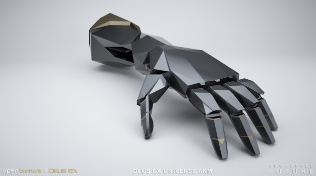
Prosthetic arms inspired by 'Deus Ex' are coming next year

Remember that prosthetic arm, inspired by Metal Gear Solid, that Konami developed for a British amputee? Well, it seems the company has started a trend. Square Enix and Eidos-Montréal have now teamed up with Open Bionics, a specialist in low-cost prosthetics, to develop some designs based on the world of Deus Ex. The franchise delves deep into a possible future where human augmentation is commonplace, changing society and warfare in equal measure. Two arms -- one based on Adam Jensen, the hero of Mankind Divided, another on the wider Deus Ex universe -- will be released next year as royalty-free designs that anyone can use.
Open Bionics has already made prosthetic arms inspired by Iron Man,Frozen and Star Wars. The new designs look more impressive, however; the Adam Jensen arm (below) is full of detail, from its flexing fingers to the rotating wrist. The Titan arm (above), meanwhile, is more stylized with sharp, geometric shapes and angles. Both are colored in gunmetal grey and gold, reflecting the series and its augmented superhero.
Eidos-Montreal and Open Bionics will be showing the arms at multiple game shows including E3 and Gamescom, with a little help from Razer. The company, most known for its gaming keyboards and mice, will be using itsStargazer webcam to track people's movements and show them what it would be like to control an artificial limb. They might not be as lethal as those used by Adam Jensen, but they look the part -- if they perform half as well, they could be attractive to amputees with a passion for the franchise.

Wildfire on the Kamchatka Peninsula

On June 7, 2016, the Visible Infrared Imaging Radiometer Suite (VIIRS) on the Suomi-NPP satellite captured this natural-color image of a large wildfire burning in Russia near the west coast of the Kamchatka Peninsula. Red outlines indicate hot spots where VIIRS detected warm surface temperatures associated with fires. Smoke from the wildfire was drawn into the circulation of a weak area of low pressure over the Sea of Okhotsk, the University of Wisconsin CIMSS satellite blog noted.Beneath the smoke, a deck of low-level stratus cloud is also visible.


Volcanoes of Kamchatka
acquired September 12, 2014
In 1996, when the United Nations was considering whether to add the volcanoes of the Kamchatka Peninsula to its list of World Heritage sites, the committee was asked to consider what made those volcanoes more worthy of preservation than the many others around the world. At the time, several volcanoes were already on the list, and three others were under consideration.
The answer was reminiscent of something that explorer Stepan Krasheninnikov pointed out in 1755. “Perhaps there is no other region in the world where so many volcanoes and hot springs are to be found in so small a space as here on Kamchatka,” he wrote in Description of Kamchatka Land. Indeed, the peninsula’s location on the Ring of Fire puts it in one of the most geologically active zones on the planet. There are more than 300 volcanoes on the Kamchatka peninsula, including 29 that are active.
But Kamchatka’s volcanoes are remarkable for more than their numbers. “Geologists classify volcanoes by form and by eruptive habits,” the nominators wrote, “and once again Kamchatka stands out as having the greatest variety of types, more so than any other area and than in any other existing World Heritage site.”
Thanks to clear weather on September 12, 2014, the Operational Land Imager (OLI) on Landsat 8 captured a series of images that showcases the geologic diversity of Kamchatka’s volcanoes. This mosaic includes six scenes stitched together from the September 12 flyover. Use the gigapan browser below to explore the image in more detail.

From geographic north to south, the erupting volcanoes are Shiveluch, Bezymianny, Kizimen, Karymsky, and Zhupanovsky.Several volcanoes were erupting simultaneously, sending faint plumes of ash and gas drifting southeast. Smoke from a wildfire burning north of Shiveluch is also visible.
The tallest of the group is Shiveluch, a steep-sloped stratovolcano, that reaches 3,283 meters (10,771 feet) above sea level. The most active is Karymsky, a 1,536-meter (5,039-foot) peak that has erupted regularly since 1996. The Shiveluch and Bezymianny eruptions are both characterized by growing lava domes—thick, pasty lava that forms a mound as it is extruded. Kizimen’s lava is not as viscous as that at Shiveluch and Bezymianny. The intermediate lava forms thick, blocky flowsbordered by tall levees. Rocks and ash frequently fall from Kizimen’s summit and the fresh lava flow on its eastern flank, creating dark, fan-shaped debris deposits.
Kamchatka’s volcanoes are also defined by their inaccessibility. Fewer than 350,000 people live on the peninsula, with most of them in Petropavlovsk-Kamchatsky. Broad swaths of the peninsula lack roads, and helicopters are the only way to get around in some areas.
The logistical challenges associated with installing and maintaining ground-based sensors make satellites a necessity for monitoring Kamchatka’s volcanoes. “There are several volcanic phenomena that lend themselves to remote detection and monitoring: eruption plumes laden with ash, sulfur dioxide, and water; low-temperature anomalies such as crater lakes and fumaroles; high-temperature anomalies, such as lava flows, pyroclastic flows, and lava domes; and deformation of the volcanic edifice,” explained Michael Abrams, a NASA scientist and the leader of the ASTER science team, in a chapter of theEncyclopedia of Remote Sensing.

Τετάρτη 8 Ιουνίου 2016

Technology partnership to provide vital new information to coastal engineers

Technology partnership to provide vital new information to coastal engineers

June 08, 2016
The National Oceanography Centre (NOC) has entered into a two year Knowledge Transfer Partnership (KTP) with Marlan Maritime Technologies Ltd to develop innovative remote sensing services for the survey of intertidal zones.
The partnership builds on the existing collaborative R&D between Marlan, the NOC and the University of Liverpool which included a successful ERDF-funded collaboration as part of the University’s Centre for Global Eco-Innovation (CGE) and resulted in a technique (previously prototyped by the NOC’s Paul Bell being validated and refined by the Marlan sponsored CGE researcher Cai Bird during his PhD) being patented. The new project will see NOC’s Dr Paul Bell and KTP Associate Dr Cai Bird work with Marlan over the next two years to develop and then test new techniques that will ultimately provide improvements to the quality and efficiency of delivering data services to the coastal engineering industry. These services will enable more cost effective monitoring, design and construction of coastal and maritime infrastructure.


The data is collected by Marlan using its remote sensing platform which includes a standard ship’s radar to visualise the location of the ‘waterline’ between wet and dry regions. The rise and fall of the tide and consequent movement of the waterline is used to build up a three-dimensional map of the coastline covered by the tidal ebb and flow – the intertidal areas. This is an old idea dating as far back as World War One using aerial photos, brought right up to date using radars and newly developed robust software algorithms. This allows new maps of the intertidal beach areas to be produced automatically every couple of weeks, and those maps show how the coastline evolves over time. Beach surveys are difficult and expensive to produce, so are rarely performed routinely, and never at the rate this system can achieve. These evolving maps show how and when beaches change; providing the information needed for the management of key stretches of coastline or erosion hotspots.


The services are expected to appeal to the UK’s 50 coastal councils, as well as, for example, operators of ports, coastal power stations, desalination plants, transport infrastructure, sewage treatment works, coastal engineering consultancies, research groups and military sites. The patent also covers Europe, Australia and the USA, and so an additional 1.1 million km of coastline can be considered for potential sites.


Alex Sinclair, Managing Director of Marlan Maritime Technologies Ltd commented “Currently, we can offer this service to just a handful of customers a year, but by the end of the project we expect to be able to meet the needs of potentially hundreds and then thousands of users worldwide. Everyone we talked with is excited at the prospect of having data like this which will provide deeper understanding of the processes acting in complex coastal domains. We are delighted to be providing this information, which is such a valuable tool for protecting people, places and profits in maritime environments."


Kevin Forshaw, Associate Director, Innovation and Enterprise at the NOC commented “The NOC is confident that this partnership will see the benefits of coastal knowledge transferred from the science community to UK industry, and probably beyond, for the good of all coastal communities.”
Dr Paul Bell added “The ability to conduct intertidal beach surveys every couple of weeks using a robust and automated remote sensing system will provide an unprecedented window on the way key areas of coastline respond to storms, recover in calmer weather, and evolve following any coastal engineering works. This Knowledge Transfer Partnership with Marlan will massively accelerate and facilitate the shift of this cutting edge development from the realms of a research project to a fully-fledged commercial service.”


Prof. Andy Plater, support academic on the KTP from the University of Liverpool, emphasized, “Our success is down to the close research collaboration between the University of Liverpool, NOC and Marlan that emerged from our Centre for Global Eco-Innovation. The KTP will enable us to further develop the outputs of Cai’s PhD research, and is a great example of the commercial and societal impact that can be achieved by connecting world-leading research expertise with the innovative thinking and inspiration of SMEs like Marlan.”


NOC KTP Associate Dr Cai Bird added, "This knowledge transfer partnership represents an excellent and unique opportunity to see the direct implementation of our academic research into commercial systems. I am passionate about the potential for this technology to fill a crucial gap in the nearshore survey industry and look forward to developing and deploying radar survey systems over the duration of this project and beyond." 


The teamThe team
The project is being funded through Innovate UK following a successful joint bid application from the NOC and Marlan.