BIG BANG NEWS
RESEARCH, TECHNOLOGY, SCIENCE, DIACHRONIC NEWS, COMMENTS, ,SPORTS,MUSIC,SKY AND STARS,AND MUSH MORE.

Αναζήτηση αυτού του ιστολογίου

Τετάρτη 15 Νοεμβρίου 2017

13 ΝΕΚΡΟΙ ΚΑΙ ΠΟΛΛΟΙ ΑΓΝΟΟΥΜΕΝΟΙ-Συγκλονιστικές εικόνες - Βιβλική καταστροφή με νεκρούς στη Μάνδρα Αττικής


Flash Flooding in Western Athens Leaves Catastrophic Damage, Almost a Dozen Dead
Torrential rains and flash flooding in the outskirts of western Athens have caused catastrophic damage, leaving almost a dozen people dead.
As the story is still evolving, the Greek Coast Guard is pulling bodies from the sea. Reports of at least seven people swept away by the flash floods have been confirmed by authorities, as well as five people found dead in their flooded homes.
A section of the highway between Athens and Corinth that connects the Greek mainland with the Peloponnese was inaccessible, with floodwaters overcoming an underpass.
Most of the flood’s impact happened in the areas of Mandra, Nea Peramos and Megara, in the outskirts of western Athens.
“This is a biblical disaster,” Mandra Mayor Yianna Krikouki told state broadcaster ERT. “Everything is gone.”
More bad weather has been forecast for various areas of Greece in coming days.

Τετάρτη 1 Νοεμβρίου 2017

Σάββατο 7 Οκτωβρίου 2017

Descubren brazo de bronce en el naufragio de Antikythera

Brazo apunta a la existencia de al menos siete estatuas del naufragio griego, la fuente de la más extensa y excitante carga antigua jamás encontrada

naufragio
BRETT SEYMOUR/EUA
Los arqueólogos marinos han recuperado un brazo de bronce de un antiguo naufragio de la isla griega de Antikythera, donde se cree que permanecen enterrados los restos de al menos siete estatuas más valiosas del mundo clásico.
Los buzos encontraron el brazo derecho, incrustado y manchado verde, debajo de medio metro del sedimento en la cuesta rocosa-esparcida donde el barco y su carga. El enorme buque, tal vez de 50 metros de proa a popa, estaba navegando desde Asia Menor a Roma en el año 1BC cuando se hundió cerca de la pequeña isla entre Creta y el Peloponeso.
El equipo del proyecto, del Ephorate griego de las antigüedades subacuáticas y la universidad de Lund en Suecia, descubrió el brazo enterrado con un detector subacuático hecho a la medida del metal que ha revelado la presencia de otros objetos grandes del metal debajo del fondo del mar. “Debería haber al menos siete estatuas”, dijo Alexandros Sotiriou, un buzo técnico griego del equipo. La operación es supervisada por Ageliki Simosi, director del Ephorate griego de las antigüedades subacuáticas, que es responsable de toda la arqueología subacuática en Grecia.
“Lo que estamos encontrando es que estas esculturas están entre y debajo de las rocas”, dijo Brendan Foley, codirector del equipo de excavaciones de la Universidad de Lund. “Creemos que significa un mínimo de siete, y potencialmente nueve, esculturas de bronce que aún nos esperan allá abajo”. Las rocas que cubren los objetos de metal pesan varias toneladas y pueden haber caído sobre el naufragio durante un terremoto masivo que sacudió a Antikythera y sus alrededores islas en el siglo IV dC.
El brazo de bronce, probablemente de una estatua de un hombre, es el punto culminante de la temporada de excavación del equipo 2017. Entre otros objetos, los buzos recuperados son una losa modelada de mármol rojo del tamaño de una bandeja de té, una jarra de plata, secciones de madera unida del bastidor de la nave y un hueso humano. El año pasado, el equipo encontró el cráneo, dientes, costillas y otros huesos de un individuo que pereció en el naufragio. Desde entonces han extraído el ADN del cráneo y de él aprendió el sexo del individuo y de dónde vinieron. Hasta que esos resultados se publican, la persona es conocida como Pamphilos después de que los buceadores encontraron el nombre, que significa “amigo de todos”, tallado en una taza enterrada que había sido decorada con una escena erótica.

Παρασκευή 29 Σεπτεμβρίου 2017

MARS Evidence of an ancient lake

Ancient Lake On Mars Was Hospitable Enough To Support Life
An illustration showing how the lake in the crater might have looked.
Credit: NASA/JPL-Caltech/ESA/DLR/FU Berlin/MSSS
An up-close view of Mars' rocky deposits by NASA's Curiosity rover shows a changing climate in the planet's ancient past that would have left the surface warm and humid enough to support liquid water — and possibly life. Evidence of an ancient lake points to the prospect of two unique habitats within its shores; the lower part of the lake was devoid of oxygen compared to an oxygen-rich upper half. 
In a recent paper published in the journal Science, Redox stratification of an ancient lake in Gale crater,” Stony Brook University geoscientist Joel Hurowitz and his colleagues used more than three years of data retrieved from the rover to paint a picture of ancient conditions at Gale Crater, the lowest point in a thousand kilometers. The site, a 150-mile kilometer crater formed during an impact around 3.8 billion years ago, once flowed with rivers ending in a lake. The sedimentary rocks laid down by these rivers and onto the lakebed tell the story of how the environment changed over time.
Curiosity landed on a group of sedimentary rocks known as the Bradbury group. The rover sampled a part of this group called the Sheepbed mudstones, as well as rocks from the Murray formation at the base of the 5-kilometer high peak at the center of the crater known as Mount Sharp. Both types of rocks were deposited in the ancient lake, but the Sheepbed rocks are older and occur lower in the stratigraphic layers of rocks. Comparing the two types of rocks can lead to interesting revelations about the paleoenvironment. 
Rocks that form at the same time in the same area can nevertheless display differences in composition and other characteristics. These different groupings are known as "facies” and the Murray formation is split into two facies. One is comprised mainly of hematite and phyllosilicate, and given the name HP, while the other is the magnetite-silicate facies, known as MS. 
"The two Murray facies were probably laid down at about the same time within different parts of the lake," explained Hurowitz. "The former laid down in shallow water, and the latter in deeper water."
The near-shore HP facies have thicker layers in the rocks compared to the thin layers of the deeper water MS facies. This difference in layer thickness is because the river flowing into the lake would have slowed down and dumped some of its sedimentary material at the lake shore. The flow would then have spread into the lake and dropped finer material into the deeper parts of the lake. 
Curiosity landed on rocks known as the Bradbury group. The Murray formation consist of younger rocks at the base of Mount Sharp. The height is exaggerated in the diagram.
Credit: NASA/JPL-Caltech
The different mineralogy of the two facies was caused by the lake becoming separated into two layers. Ultraviolet (UV) radiation along with low levels of atmospheric oxygen penetrated the upper part of the lake and acted as oxidants on molecules in the water. These ions of iron (Fe2+) and manganese (Mn2+) were brought to the lake via seepage of groundwater through the lake floor.
When the UV and oxygen interacted with these, they lost electrons, meaning that they had become "oxidized." The oxidized iron and manganese precipitated into minerals — hematite and manganese oxide — that eventually made up the rocks sampled by Curiosity in the HP facies. However, the UV and oxygen didn't reach all the way to the lake floor, so the iron and manganese wasn't oxidized in the deeper part of the lake, and instead became the mineral known as magnetite, making up the MS facies. 
The difference in oxidation of the two facies in the Murray formation due to differences in layers of the lake is known as redox stratification. Identifying redox stratification in the ancient lake shows that there were two completely different types of potential habitat available to any microbial life that might have been present.
The researchers also discovered that the Murray formation has a high concentration of salts, which provide clues relating to evaporation of the lake, and thus the end of the potential habitat. High salinity is a result of water evaporating and leaving salts behind. However, evaporation leaves other tell-tale signs such as desiccation cracks — similar to what you see when mud dries and cracks — and none of these signs appear in the Murray formation. This indicates that the evaporation occurred at a later period of time and that the salts seeped through layers overlying the Murray formation before becoming deposited in the Murray rocks. 
"Curiosity will definitely be able to examine the rocks higher up in the stratigraphy to determine if lake evaporation influenced the rocks deposited in it," said Hurowitz. "In fact, that's exactly what the rover is doing as we speak at the area known as Vera Rubin Ridge."
Once Curiosity examines these rocks, it will be able to confirm that the salts found in the Murray formation came from a later period of evaporation, and therefore no significant evaporation occurred during the time that the Murray formation was deposited, meaning the environment would have been stable enough to support possible life forms.
The inflowing river deposits thicker material (clastics) close to the lake shore, and finer material towards the deeper part of the lake. The incoming UV and O2 oxidizes the iron and manganese in the upper part of the lake, but not the lower part of the lake. This creates what is known as redox stratification and is reflected in the different mineralogy of the two different facies of the Murray formation.
Credit: Hurowitz et al. (2017). Science.
Another result of the research is evidence of climate change. The older Sheepbed formation shows very little evidence of chemical weathering compared to the Murray formation. The change to substantial chemical weathering in the younger rocks indicates that the climate likely changed from cold, arid conditions to a warm, wet one. 
"The timing of this climate shift is not something we can tell for sure because we haven't seen the Sheepbed member and the Murray formation in contact with each other," said Hurowitz. "If we had, then we might be able to tell if the change in their chemical and mineralogical properties were abrupt (indicating rapid climate change) or gradual. At best, what we can say is that the rocks that we examined were likely deposited over a timespan of tens of thousands of years to as much as around 10 million years."
The cause of the climate change on Mars is still a matter of debate. If the climate changed in a short period of time, it could have been due to short-term variations or an asteroid impact. A slower change in climate could have been the result of changes in the obliquity cycle of the planet.
The climate change indicated in the rocks shows that the ancient Martian environment would have been warm and humid enough to sustain liquid water on the surface. The redox stratification of the lake as revealed by the different mineralogy in the Murray formation shows that there would have been two different environments within the lake itself. If microbial life was present on Mars at this time, the different potentially habitable niches could have encouraged diversity with anaerobic forms possibly living in the lower depths of the lake. 
"I'm not sure that this was something we would have predicted if we hadn't had the opportunity to examine Gale's rock record up close and personal," adds Hurowitz.

Σάββατο 9 Σεπτεμβρίου 2017

As hard as Hurricane Irma did


Communications in and out of the BVI are still mostly down, but we have a satellite phone working to share updates. Yesterday afternoon and today we have travelled to Virgin Gorda to try to do everything we can to help the community. The wonderful team have been going around to all of our team members on Virgin Gorda to check they are safe and well. There is a huge amount of damage to buildings, but fortunately everyone we have seen so far has been ok.

The boats are piled up like matchsticks in the harbour. Huge cargo ships were thrown out of the water and into rocks. Resorts have been decimated. The houses have their roofs blown off; even some churches where people sheltered have lost roofs. But the whole British Virgin Islands community is rallying round.


Image from Caribbean Buzz Helicopters


There needs to be an enormous aid effort. Please get the word out to anyone who can help further. We have Necker Belle coming in from Barbados with food, water and supplies and we hear others are sending boats. Governments – the UK in the British Virgin Islands, the US in the US Virgin Islands - need to do all they can to help people here who have lost their homes and in many cases will have lost their livelihoods after the storm. Thank you to everyone who has donated to the British Red Cross so far – please keep donating at Virgin Money Giving.

21371183_1542776015782206_8645058114706347920_n.jpg

Image from Caribbean Buzz Helicopters


It really was the storm of the century, but another one is coming. We are hopeful Hurricane Jose will not hit the BVI as hard as Hurricane Irma did, but urging everyone to get prepared and helping with supplies where we can.

Man-made climate change is contributing to increasingly strong hurricanes causing unprecedented damage. The whole world should be scrambling to get on top of the climate change issue before it is too late – for this generation, let alone the generations to come.


Image from Caribbean Buzz Helicopters


In the meantime, our focus is on making sure people are safe, have shelter, food and water. I will try to keep you all updated, hopefully electricity will return soon and more people can get in touch with loved ones. Sending love from everyone here to everyone supporting from afar, it is hugely appreciated.

Hurricanes and Animals


More than 50 Caribbean flamingos take shelter in a men's restroom at the Miami Metrozoo (now Zoo Miami) on Sept. 25, 1998. Zookeepers rounded up the birds to protect them from the effects of Hurricane Georges. This was not the first time the zoo had to corral flamingos in a restroom. They were also in there during Hurricane Andrew, six years earlier.
Max Trujillo/Getty Images
When you're building a zoo disaster plan, there's one thing to keep in mind: Murphy's law. Anything that could go wrong, will.
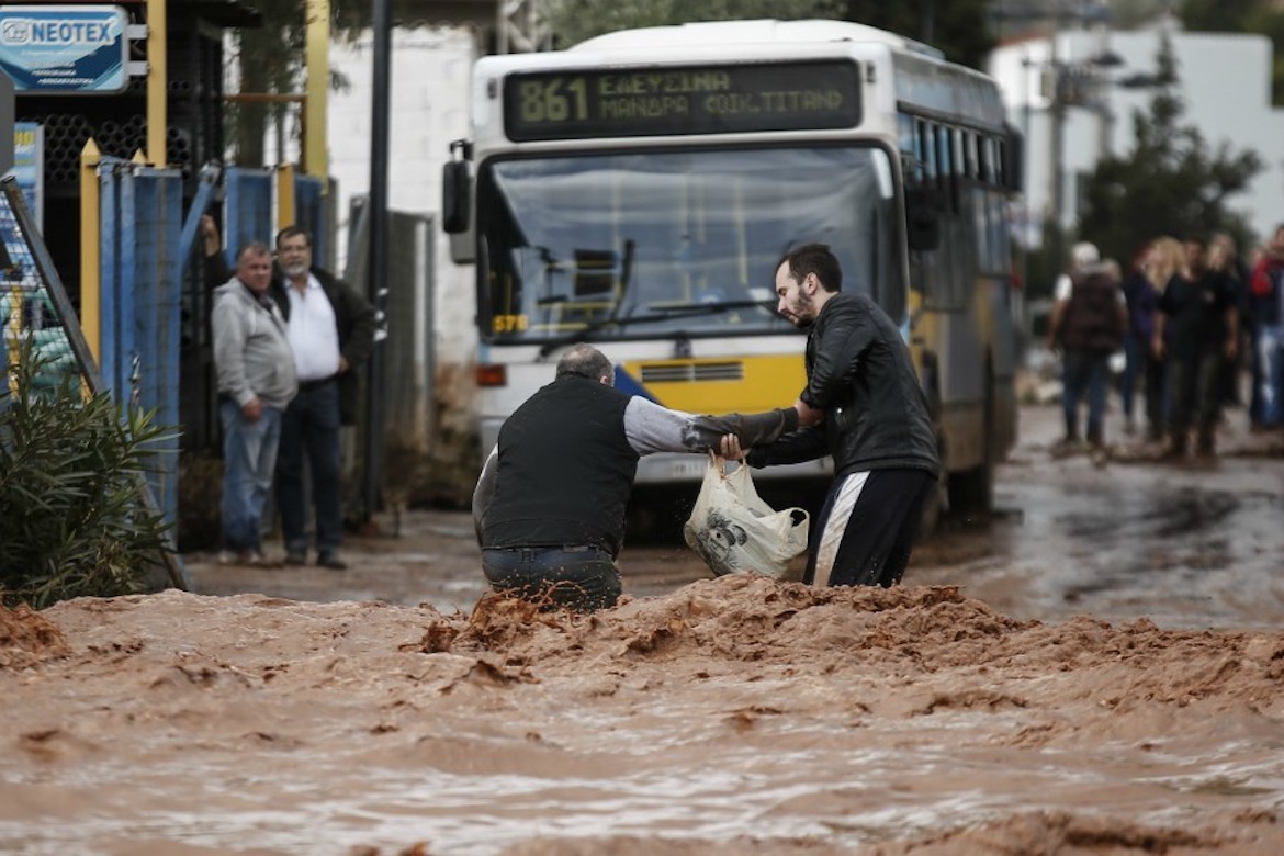
Just ask the flock of flamingos that weathered Hurricane Andrew in a public restroom at Zoo Miami in 1992.
Or, you could ask the zoo personnel across the coast who've been running emergency drills since the start of hurricane season.
The Association of Zoos and Aquariums, which represents more than 230 animal care facilities in the U.S. and abroad, requires all of its members to practice an annual disaster preparedness drill to keep their accreditation. And many facilities review or update their protocols every year, including Zoo Miami, which is now buckling down as Hurricane Irma approaches Florida.
Meal prep
The skeleton of a zoo disaster plan is similar across the board: Staff members remove loose debris from the park, tarps and signs are taken down, generators and gas tanks are prepped. Cleaning supplies and food for animals and staff are stockpiled in advance — basically anything the zoo can prepare to operate without any outside assistance.
Facilities will also often choose members of a ride-out crew: select facilities staff, animal nutritionists and other key team members who will bunker down at the zoo through the storm. Lee Ehmke, CEO of the Houston Zoo, says 15 team members stayed on the first night of Hurricane Harvey last month.
"We were sleeping here at the zoo, on cots or on the floor," he says. "We prepared food so everyone was fed ... There was a lot of radio and Internet communication to make sure the right diets were given to the animals."
Backups for your backup
Beyond the standard operating procedures, emergency protocols vary somewhat from zoo to zoo — something AZA spokesman Rob Vernon says is intentional.
"We don't necessarily say, 'Here's the plan, just insert your name here,' " he says. "We definitely have guidelines, but we leave it up to each facility to come up with their own plan because each one is unique."
Rich Toth, vice president and managing director of downtown facilities at the Audubon Nature Institute, says they have several tiers of energy at the ready — including primary power, secondary power and backups for the backup.
And because the Audubon also oversees an aquarium, which faces different challenges than its zoo in disaster situations, it needs those extra safety nets.
A penguin rescued in the aftermath of Hurricane Katrina swims in its old habitat in the Audubon Aquarium of the Americas on May 22, 2006, after returning to New Orleans following an eight-month refuge in California.
Mario Tama/Getty Images
When Hurricane Katrina hit New Orleans' Audubon Aquarium of the Americas in 2005, it knocked out the emergency generator, killing a large portion of the aquatic collection.
"While we did have some fish make it, the animals that made it were almost all our air-breathers, if you will," Toth says. "So our bird collection, including our penguins. Our sea otters were fine. Our large green sea turtle."
He says staff members were able to pack up and temporarily relocate those animals to other AZA zoos and aquariums after the storm passed, but it's tougher when you're dealing with fish. For one, water is heavy — but also, a fish's respiration and bodily functions greatly depend on the water it's already in. So, for the most part, it's best to just try to weather the storm in-house.
"We are never going to evacuate"
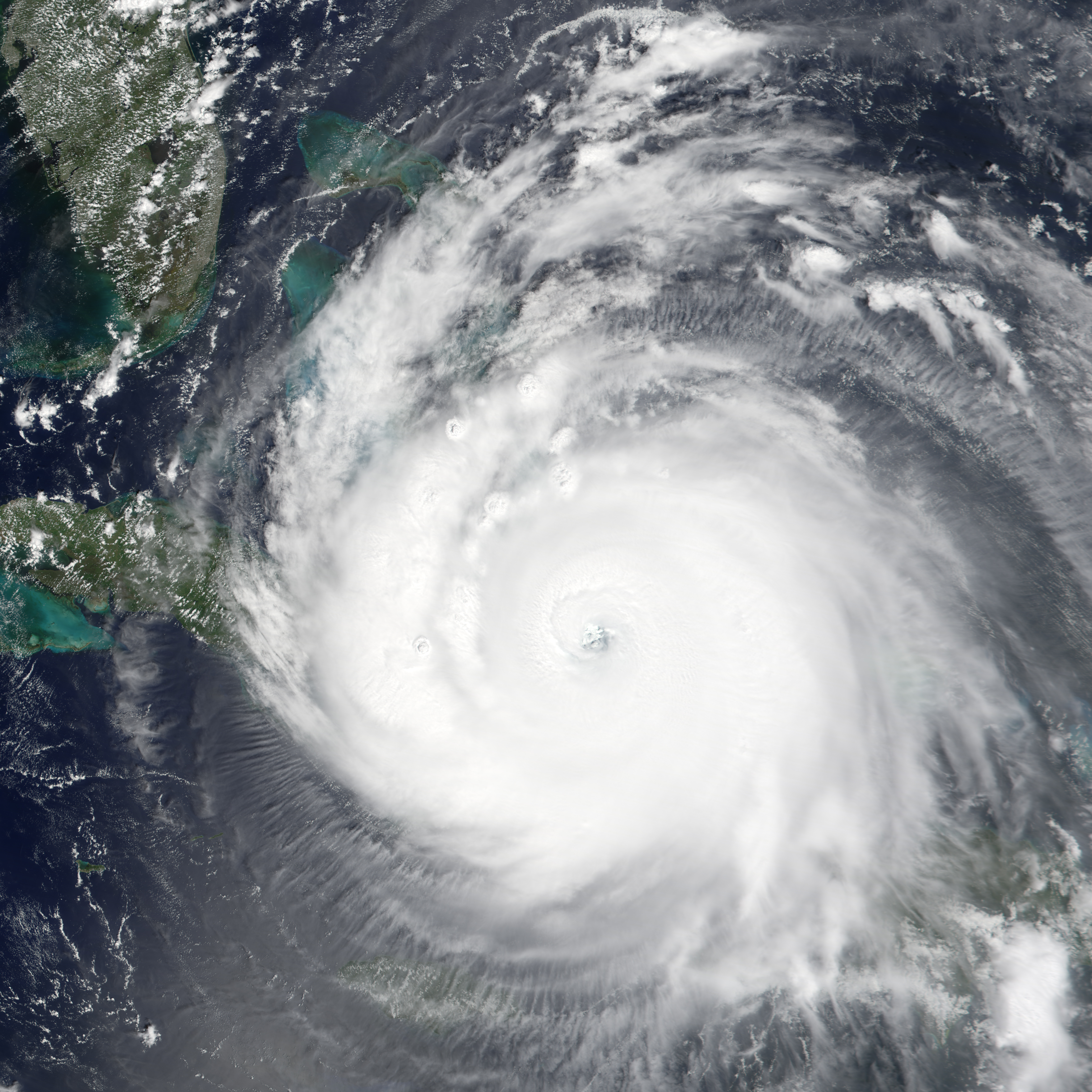
In preparation for Hurricane Irma this week, Zoo Miami's plan is to stay put, too, says communications director Ron Magill. The reasoning, in part, is because the path of hurricanes can change quickly, and transporting an animal could actually mean moving it into more danger.
"That's probably the No. 1 question I get asked: 'Oh my God, when are you going to evacuate animals?' We are never going to evacuate animals," Magill says.
He says the stress of evacuating alone can be enough to kill an animal. Instead, the birds and small mammals of Zoo Miami will ride out the storm in independent kennels or buildings. The larger residents, particularly the carnivores and great apes, will bunker down in their usual indoor holding areas.

The zoo has reserved in advance a freezer and refrigerator truck, a practice it picked up after Hurricane Andrew blew away its walk-in freezers and refrigerators, Magill says."Those night houses are made of poured concrete, welded metal, to withstand the strength of the animal itself," Magill says. "And fortunately, it's also strong enough to withstand the strength of a major hurricane."
That element of adapting is key when preparing for disasters at animal care facilities — learning from past surprises to better prep for the future.
Zoo Miami's former aviary, Wings of Asia, for example, was decimated by Hurricane Andrew, despite the staff's prior preparation.
"Although the netting for that aviary was tested for 150 mph winds," Magill says, "it was not tested to be able to withstand the impact of a mobile home that was picked up in those winds and launched into the aviary like a torpedo."
Wings of Asia was where Zoo Miami took its greatest losses during Hurricane Andrew, which killed nearly 100 birds. Throughout the rest of the zoo, Magill says, only five animals died.
A very big family
In the aftermath of Hurricane Harvey, several zoos and aquariums reportedly brought supplies and aid to facilities that were heavily affected by the storm — including the Texas Zoo in Victoria.
Officials from the Houston Zoo, Zoo Miami and the Audubon Nature Institute confirmed that kind of collaboration is common in the community.
"The AZA-accredited facilities in particular are a very big family," Vernon says. "It's incredible to see people willing to drop everything and come down to Texas and help in any way they need it."

"Many of them did have significant damage or may have actually lost their homes in the flood," Ehmke says, "including a number who spent time here helping take care of the animals and the facility while their personal belongings were in danger."But that community extends beyond ensuring the welfare of their animals. A major priority for zoos after natural disasters is their staff members, some of whom might have lost everything in the storm or flooding.
"We're going to do what we can to assist our employees as we get a clearer picture of the extent of their losses," he says.
In response, the AZA has set up a Hurricane Harvey Relief Fund across its network to raise money for employees and their families affected by the storm and flooding. Vernon says the organization will likely establish a similar fund after Hurricane Irma, should it hit any AZA facilities.
"We became a better zoo"
Looking ahead this week to Hurricane Irma, Magill says it unfortunately isn't Zoo Miami's first rodeo. But having survived previous disasters, he is confident the zoo and its animals will come out OK.
"For a lot of people — and I'm speaking for myself in Andrew — the zoo became almost a haven for us," Magill says. "We became a better zoo. And as bad as this storm looks, I know we'll be able to make it through this also."

IN some respects, Irma is an unusual and record-breaking storm.


acquired September 8, 2017download large image (4 MB, JPEG, 4095x2730)


Meteorologists struggled to find the right words to describe the situation as a line of three hurricanes—two of them major and all of them threatening land—brewed in the Atlantic basin in September 2017.

Forecasters were most concerned about Irma, which was on track to make landfall in densely populated South Florida on September 10 as a large category 4 storm. Meanwhile, category 2 Hurricane Katia was headed for Mexico, where it was expected to make landfall on September 9. And just days after Irma devastated the Leeward Islands, the chain of small Caribbean islands braced for another blow—this time from category 4 Hurricane Jose.

The Visible Infrared Imaging Radiometer Suite (VIIRS) on the Suomi NPP satellite captured the data for a mosaic of Katia, Irma, and Jose as they appeared in the early hours of September 8, 2017. The images were acquired by the VIIRS “day-night band,” which detects light signals in a range of wavelengths from green to near-infrared, and uses filtering techniques to observe signals such as city lights, auroras, wildfires, and reflected moonlight. In this case, the clouds were lit by the nearly full Moon. The image is a composite, showing cloud imagery combined with data on city lights.

The Moderate Resolution Imaging Spectroradiometer (MODIS) on NASA’s Terra satellite acquired a natural-color image of Irma (below) at 10:00 a.m. local time (16:00 Universal Time) on September 8, 2017.


The NASA Short-term Prediction Research and Transition Center remarked on the storm’s “buzzsaw appearance.” The National Weather Service field office in Miami warned of “large airborne projectiles” and cautioned that some locations may be “uninhabitable for weeks or months” after the storm. Eric Blake, a meteorologist with the National Hurricane Center, simply tweeted that he had “never seen anything like this in the modern record” and that the forecast made him “sick to his stomach.”

In some respects, Irma is an unusual and record-breaking storm. On September 8, the storm had generated more accumulated cyclone energy—a term meteorologists use to describe the destructive potential of a hurricane—than any other Atlantic storm on record, according to meteorologist Philip Klotzbach of Colorado State University. Irma also broke a record for generating the most accumulated cyclone energy in a 24-hour period.

As all three storms approach land, meteorologists will be using assets on the ground, in air, and in space to track them. “Our human assets and aircraft penetrations are critical but limited,” said Marshall Shepherd, an atmospheric scientist at the University of Georgia. “Satellites provide a unique perspective on clouds, rainfall, sea surface state, sea surface temperature, and more. Only the satellite vantage point can provide continuous coverage of all three storms without having to refuel or sleep.”

Παρασκευή 8 Σεπτεμβρίου 2017

Earthquake Hits Mexico M 8.1 - Sep 8th 2017 tsounami alert


At least five have been killed including two children after a massive 8.1 earthquake struck off the south coast of Mexico triggering a tsunami. The earthquake was felt across Mexico, toppling houses and shaking buildings in the country's capital amid reports tremors were detected as a far away as Austin, Texas - more than 1,300 miles from the epicentre. A tsunami has already been detected in Mexico after the quake struck at 11.49pm last night, 76 miles southwest of the town of Pijijiapan, at a depth of 43 miles. Terrified residents in Mexico City ran out into the streets after the quake struck, witnesses said. Tremors were stronger than a devastating earthquake in 1985 that hit the capital flattening swathes of the city and killing thousands. The US Tsunami Warning System said widespread hazardous tsunami waves were possible within the next three hours on the Pacific coasts of several central American countries - Mexico, Guatemala, El Salvador, Costa Rica, Nicaragua, Panama, Ecuador and Honduras. Seismologists have warned of a tsunami of more than 12 ft. As far as 8700 miles away in the Philippines, the national disaster agency put the country's entire eastern seaboard on alert. The only tsunami detected so far, however had a largest wave measured at 2.3ft, experts said. The death toll has already risen to at least five people, including two children in Tabasco state. Tabasco Gov. Arturo Nunez said that one of the children died when a wall collapsed, and the other was a baby who died in a children's hospital that lost electricity, cutting off the supply to the infant's ventilator. The other three deaths were in Chiapas state, in San Cristobal de las Casas, with two crushed when buildings collapsed on them. The quake hit offshore in the Pacific, the US Geological Survey said, putting the magnitude at 8.1. But Mexico's seismologic service gave a magnitude of 8.4, which if confirmed would be the most powerful ever recorded in this quake-prone country. Terrified residents fled into the streets amid chaotic scenes in the wake of the huge tremor. 'The house moved like chewing gum and the light and internet went out momentarily,' said Rodrigo Soberanes, who lives near San Cristobal de las Casas in Chiapas, a poor, largely indigenous state popular with tourists. Chiapas Gov. Manuel Velasco told television station Televisa the roofs of homes and a shopping centre had collapsed in San Cristobal. 'There are damages in hospitals that have lost energy,' he said. 'Homes, schools and hospitals have been affected.' Civil Defense in Chiapas said on its Twitter account that its personnel were in the streets aiding people and warned residents to prepare for aftershocks. Buildings swayed strongly for more than one minute, loosening light fixtures from ceilings. Helicopters crisscrossed the sky above Mexico City with spotlights. Some neighborhoods kept electricity while others remained in darkness.