BIG BANG NEWS
RESEARCH, TECHNOLOGY, SCIENCE, DIACHRONIC NEWS, COMMENTS, ,SPORTS,MUSIC,SKY AND STARS,AND MUSH MORE.

Αναζήτηση αυτού του ιστολογίου

Δευτέρα 18 Αυγούστου 2014

ΕΔΩ ΒΡΙΣΚΕΤΑΙ Ο ΧΡΥΣΟΣ ΟΛΟΥ ΤΟΥ ΚΟΣΜΟΥ!How They Built Fort Knox Gold Bullion Depository

Σε αυτή την εποχή των ηλεκτρονικών πληρωμών και συναλλαγές χωρίς μετρητά, μερικές φορές είναι εύκολο να ξεχνάμε ότι η αξία των χρημάτων μας είναι στην πραγματικότητα βασίζεται εν μέρει σε μια πολύ πραγματική ουσία - χρυσό. Από το 1900 έως το 1971, όλα Ηνωμένες Πολιτείες νόμισμα που λειτουργεί κάτω από το χρυσό πρότυπο. Θεωρητικά, κάθε δολάριο χαρτί τυπωμένο από το Νομισματοκοπείο των ΗΠΑ υποστηρίχθηκε από ένα ισοδύναμο ποσό της κυβέρνησης χρυσού. Σύμφωνα με τον κανόνα του χρυσού, ο καθένας θα μπορούσε να περπατήσει επάνω σε ένα γραφείο τράπεζα νόμισμα και δολάρια χαρτί αντάλλαγμα για το επιτόκιο της αγοράς αξίας του χρυσού. Για σχεδόν 80 χρόνια, ένα πολύ μεγάλο μέρος του χρυσού της Αμερικής έχει κρατηθεί ως αποθεματικό στην Bullion Αποθετήριο ΗΠΑ, ευρύτερα γνωστή ως Fort Knox . Και ακόμα κι αν σβήσει το χρυσό πρότυπο το 1971, η ιδέα ότι τα δισεκατομμύρια δολάρια την αξία των ράβδων χρυσού είναι απλά κάθεται στο Fort Knox σκονίζονται, είναι μια δελεαστική φαντασίωση για κάθε εγκληματικός εγκέφαλος. Αλλά ακριβώς πόσο χρυσό φυλάσσεται στο Φορτ Νοξ;
Πόσο Gold είναι στο Φορτ Νοξ;
Fort Knox βρίσκεται στο Fort Knox, Κεντάκι στη διασταύρωση της Gold Vault δρόμου και Bullion Boulevard. Χτίστηκε το 1936 για να στεγάσει τα τεράστια αποθέματα χρυσού που ήρθε περίπου λόγω της εντολής που εκδόθηκε από τον Πρόεδρο Ρούζβελτ το 1933 το Εκτελεστικό Διάταγμα 6102, απαιτείται όλα τα Αμερικανούς πολίτες να εγκαταλείψουν την ιδιοκτησία των ιδιωτικών αποθεμάτων χρυσού, συμπεριλαμβανομένων των νομισμάτων, τα πιστοποιητικά και πολύτιμων μετάλλων. Η διάταξη που ουσιαστικά είναι παράνομο να κατέχει τα αντικείμενα αυτά σε ιδιώτες.Εκείνη την εποχή, η κυβέρνηση των ΗΠΑ είχε $ 4 δισεκατομμύρια  αξίας του χρυσού. Με το χρόνο ο καθένας είχε συμμορφωθεί με τη νέα τάξη πραγμάτων, το ποσό αυτό είχε διογκωθεί σε12.000.000.000 δολαρίων . Με καμία θέση για να βάλει όλες του χρυσού, η ομοσπονδιακή κυβέρνηση αποφάσισε να αναλάβει ένα τμήμα της γης που προορίζεται για τη στρατιωτική, και να οικοδομήσουν ένα τεράστιο θησαυροφυλάκιο. Κόστος κατασκευής μόλις κάτω από $ 600.000 (περίπου 10.000.000 δολάρια σε σημερινά δολάρια) και ολοκληρώθηκε το Δεκέμβριο του 1936 Το χρυσό άρχισαν να φτάνουν τον Ιανουάριο του 1937.
Gold Bars σε μια Vault
μπαρ
Το κύριο θόλο, η οποία κατέχει το χρυσό, καθώς και στοιχεία που κρίνονται σημαντικές για την εθνική ασφάλεια ή την ιστορία των ΗΠΑ, μπορεί να έχει πρόσβαση μόνο μέσω ενός 20-ton, 21-ίντσα παχιά πόρτα που είναι φακό και τρυπάνι-ανθεκτικά. Οι κωδικοί εισόδου είναι γνωστό μόνο σε έναν μικρό αριθμό εργαζομένων και δεν επιτρέπονται επισκέπτες στο κτίριο. Μέσα στο θόλο, υπάρχουν πολλά μικρότερα θησαυροφυλάκια, που καθεμία απαιτεί τη δική τους κωδικούς εισόδου τους. Μια ειδική αστυνομική δύναμη, γνωστή ως Ηνωμένες Πολιτείες Αστυνομία Νομισματοκοπείο, προστατεύει το σύνολο της ένωσης ανά πάσα στιγμή. Υπάρχουν, επίσης, εκτεταμένα συστήματα συναγερμού, κάμερες, μικρόφωνα, συρματοπλέγματα, νάρκες, ηλεκτρικούς φράκτες, πολλαπλές ελικόπτερα επίθεσης, και το πυροβολικό. Εάν ένας εργαζόμενος είναι κλειδωμένο σε, υπάρχει ένα τούνελ διαφυγής, αλλά λίγες πληροφορίες σχετικά με τη σήραγγα είναι διαθέσιμο στο κοινό.
Gold Bars στο Fort Knox
Η ποσότητα του χρυσού που πραγματοποιήθηκε στο Fort Knox έχει διακυμάνσεις κατά τη διάρκεια των ετών. Ήταν στο μέγιστο ποσό της κατά τη διάρκεια του Β 'Παγκοσμίου Πολέμου, όταν αρκετές ευρωπαϊκές κυβερνήσεις μετακόμισε αποθέματα χρυσού τους στο Κεντάκι για ασφαλή φύλαξη. Αυτή τη στιγμή, το ποσό του χρυσού στο Fort Knox κορυφώθηκε σε 20.205 μετρικούς τόνους (650 εκατομμύρια ουγκιά troy). Επίσης, κατά τη διάρκεια του 2ου Παγκοσμίου Πολέμου, τα πρωτότυπα αντίγραφα της Διακήρυξης της Ανεξαρτησίας και το Σύνταγμα των ΗΠΑ μεταφέρθηκαν στο Fort Knox, όπως ήταν οι ουγγρικές Crown Jewels και ένα αντίγραφο της Magna Carta.
Επί του παρόντος, το θησαυροφυλάκιο κατέχει 4.578 μετρικούς τόνους από 368.000 προτύπου, 400 ουγκιές troy ράβδους χρυσού. Αυτό είναι ίσο με το τρία τοις εκατό του συνόλου του χρυσού που έχει ποτέ βρεθεί και εξευγενισμένα στην ανθρώπινη ιστορία. Στο 10 Φεβ. 2014 τιμή 1276 δολάρια ανά ουγγιά, Fort Knox κατέχει περίπου περίπου 180 δισεκατομμύρια δολάριααξίας του χρυσού. Ο θόλος διαθέτει επίσης μια σειρά από σπάνια χρυσά νομίσματα. Οι ράβδοι χρυσού είναι διαφορετικής καθαρότητας. Μερικά είναι περίπου το 90% του χρυσού, καθώς δημιουργήθηκαν από έλιωσε νομίσματα. Άλλοι είναι μέντα και είναι 99% χρυσό. Είναι ενδιαφέρον, Fort Knox είναι στην πραγματικότητα δεν είναι το μεγαλύτερο χρυσό θεματοφύλακα στις Ηνωμένες Πολιτείες. Η Federal Reserve Bank της Νέας Υόρκης λειτουργεί ένα υπόγειο θησαυροφυλάκιο που περιέχει 7.000 μετρικούς τόνους χρυσού, μερικά από τα οποία ανήκει σε άλλα έθνη και κρατείται στην εμπιστοσύνη. Όποιος έχει δει Die Hard με μια εκδίκηση θα θυμούνται ότι οι κακοί προσπαθούσαν να κλέψουν το χρυσό από την Ομοσπονδιακή Τράπεζα των ΗΠΑ στη Νέα Υόρκη, χρησιμοποιώντας τεράστια φορτηγά και κατασκευή σηράγγων κάτω από την πόλη. Μεταξύ Fort Knox και το χρυσό που κατέχει στην Federal Reserve Bank στο Μανχάταν, υπάρχει περισσότερο χρυσό πραγματοποιήθηκε σε αμερικανικό έδαφος από ό, τι οποιαδήποτε άλλη χώρα στον κόσμο. Αλλά για όλα εσύ σούπερ εγκληματίες διαβάζετε αυτό, το μάθημα εδώ θα μπορούσε να ξεχνάμε Fort Knox και να επικεντρωθεί στην Fed στο Μανχάταν. δύο φορές τα κέρδη!

The United States has a large portion of its gold reserves stored in the vault at Fort Knox Bullion Depository, a fortified vault building adjacent to Fort Knox, Kentucky with the remainder split between the Philadelphia, Denver, West Point, and San Francisco Mints. Gold is not removed except for regularly scheduled audits. Domestic production of gold in the United States has been about 1 to 1.5 million ounces annually. This brings the cumulative total of US gold production to 363,000,000 troy ounces since 1792. A troy gold bar weighs 27.4 lbs or 12 kg.
In 1933, Pres. Roosevelt outlawed the private ownership of gold coins, de Leon and certificates by American citizens, forcing them to sell to the Federal Reserve. The Fort Knox gold vault was completed in 1936, at a cost of $1 million or the equivalent of $10 million today.
3.962 (1).468

Building Fort Knox Gold Depository

Fort Knox was built using 17,000 ft.³ of granite, 4,500 yd.³ of concrete, 775 tons of reinforcing steel and 700 tons of structural steel.
The facility is surrounded by fences and guarded by the United States Mint Police. Fort Knox is a US Army post of 30,000 soldiers and surrounds the depository and provides an extra level of security to the facility. The vault door and emergency door are both 21 inches thick and made of the latest torch and drill resistant metals.
In addition to the many layers of physical security. There are alarms, video cameras, minefields, barbed razor wire, electric fences, closed circuit cameras, heavily armed guards and army units. There are also Apache helicopter gunships on-site and at nearby Godman Army Airfield. Visitors are not allowed at the facility.
About 3.5 to 4 million troy ounces per year are consumed in the United States for jewelry and industrial machines. The price of gold in 1934 was about $20 and rose to between $320 to $450 per troy ounce in 1980. The current price is more than $1,200 per ounce.

Fort Knox Has Protected More Than Gold

During World War II Fort Knox held the US Declaration of Independence and the U.S. Constitution as well as reserves of European countries and key documents from Western history. The crown of St. Stephen and some of the Hungarian crown jewels were also held at Fort Knox.

Κυριακή 17 Αυγούστου 2014

The Navy’s Record-breaking Laser

The Navy’s Record-breaking Laser


A set of experiments conducted on the Nike krypton fluoride (KrF) laser at the U.S. Naval Research Laboratory (NRL) nearly five years ago has, at long last, earned the coveted Guinness World Records title for achieving “Highest Projectile Velocity” of greater than 1,000 kilometers per second (km/s), a speed equivalent to two-and-a-quarter million miles per hour.
Pictured from left to right: James (Jim) Weaver, Yefim Aglitskiy, Bruce Jenkins, Thomas (Tom) Mehlhorn, Jude Kessler, Dennis Brown, Stephen (Steve) Obenschain, Jason Bates, Victor Serlin, Steve Krafsig, Max Karasik, Lop-Yung Chan, Stephen (Steve) Terrell, Capt. Anthony Ferrari, Jaechul Oh, Sasha Velikovich, John Montgomery, and David Kehne.  (Photo: U.S. Naval Research Laboratory/Jamie Hartman)
Pictured from left to right: James (Jim) Weaver, Yefim Aglitskiy, Bruce Jenkins, Thomas (Tom) Mehlhorn, Jude Kessler, Dennis Brown, Stephen (Steve) Obenschain, Jason Bates, Victor Serlin, Steve Krafsig, Max Karasik, Lop-Yung Chan, Stephen (Steve) Terrell, Capt. Anthony Ferrari, Jaechul Oh, Sasha Velikovich, John Montgomery, and David Kehne. (Photo: U.S. Naval Research Laboratory/Jamie Hartman)
The previous record was held by researchers at Osaka University’s Institute of Laser Engineering in Japan, who in 2006 used a neodymium glass (Nd:glass) laser to accelerate a target to 700 km/s. The record, currently held by NRL, was achieved in collaboration with the NRL Plasma Physics Division and the group from Japan, demonstrating the advantages of the high uniformity and short wavelength of the KrF laser technology.
“The impact of the highly accelerated target on a stationary foil generated thermonuclear fusion neutrons whose energy spread indicated that a gigabar—that’s the pressure of a billion atmospheres—was achieved in the collision,” said Dr. Max Karasik, NRL Laser Plasma Branch.
“The results highlight the advantages of a krypton-fluoride laser in efficiently generating uniform pressures required for fuel compression in inertial confinement fusion.”
The Nike krypton fluoride (KrF) laser at the U.S. Naval Research Laboratory (NRL). (Photo provided by the Naval Research Lab/Released)
In the experiments, thin plastic foils were accelerated to 1,000 km/s over a distance of less than a millimeter. The moving foils then collided with a stationary foil, generating thermo-nuclear temperatures and neutrons from fusion reactions. The high ablative pressure applied to compress and accelerate targets is used in inertial confinement fusion and high energy density research.
NRL received the official Guinness World Records certificate, February 2014, with distinction given to the research that “…probe[s] possibilities for future clean-energy sources.” However, since the 2009 experiment, Karasik says NRL has raised the bar. With an improved laser pulse shape, researchers at the Nike laser facility have reached target velocities of 1,180 km/s.
Sponsored by the Department of Energy National Nuclear Security Administration, the Nike laser is a two to three kilojoule (kJ) KrF system that incorporates beam smoothing by induced spatial incoherence (ISI) to achieve one percent non-uniformity in single beams and 0.16 percent non-uniformity for 44 overlapped target beams.
The facility routinely conducts experiments in support of inertial confinement fusion, laser-matter interactions, and high energy density physics.
Story and information provided by the Naval Research Lab

———-
Disclaimer: The appearance of hyperlinks does not constitute endorsement by the Department of Defense of this website or the information, products or services contained therein. For other than authorized activities such as military exchanges and Morale, Welfare and Recreation sites, the Department of Defense does not exercise any editorial control over the information you may find at these locations. Such links are provided consistent with the stated purpose of this DOD website.

Πέμπτη 14 Αυγούστου 2014

The Pacific Ocean hosts a quartet of tropical cyclones

ΦΑΙΝΕΤΑΙ ΟΤΙ ΖΟΥΜΕ ΣΕ ΧΑΛΕΠΟΥΣ ΚΑΙΡΟΥΣ,Ο ΗΛΙΟΣ ΕΙΝΑΙ ΑΝΑ ΠΑΣΑ ΣΤΙΓΜΗ ΕΤΟΙΜΟΣ ΝΑ ΜΑΣ ΔΙΑΛΥΣΗ. ΜΗΠΩΣ ΕΙΝΑΙ ΚΑΙΡΟΣ Ο ΚΑΘΕΝΑΣ ΜΑΣ ΣΙΓΑ ΣΙΓΑ ΝΑ ΑΡΧΙΣΗ ΝΑ ΦΤΙΑΧΝΗ ΤΗΝ ΔΙΚΗ ΤΟΥ ΚΙΒΩΤΟ?

The Sun sported a very long filament (over 30 times the size of Earth) that angled diagonally across its surface for over a week (July 31 - Aug. 6, 2014). Filaments are clouds of cooler gas suspended above the Sun's surface by magnetic forces. They are notoriously unstable and often break apart in just hours or days. So far, this one has held together as it rotated along with the Sun for over a week. The images were taken in the 193 Angstrom wavelength of extreme ultraviolet light and were tinted red instead of its usual brown hue. Credit: Solar Dynamics Observatory/NASA.


The Pacific Ocean hosts a quartet of tropical cyclones - from left to right - Typhoon Halong, Hurricane Genevieve (which kept travelling west to become Typhoon Genevieve), Hurricane Iselle, and Hurricane Julio. In this image from 00:00 UTC on 7 August 2014, the storms are all far from land, but there are warnings for hurricane and tropical storm force winds in Hawai'i as Iselle approaches, and for high waves and heavy rain in Japan, where Halong is forecast to make landfall.

Composite image comprising infra red data from the geostationary satellites of the JMA and NOAA, overlaying NASA's Blue Marble Next Generation.


Amazon's Biggest Fish Faces Threat of Extinction


Fishing for Brazil's Fossils
.
View gallery
Villagers from the Rumao Island community carry part of their catch of arapaima or pirarucu, the largest freshwater fish species in South America and one of the largest in the world, after fishing in a branch of the Solimoes river, one of the main tributaries of the Amazon, in the Mamiraua nature reserve near Fonte Boa about 600 km (373 miles) west of Manaus, November 25, 2013. Catching the arapaima, a fish that is sought after for its meat and is considered by biologists to be a living fossil, is only allowed once a year by Brazil's environmental protection agency. The minimum size allowed for a fisherman to keep an arapaima is 1.5 meters (4.9 feet). Picture taken November 25, 2013. (REUTERS/Bruno Kelly)
Measuring 10 feet (3 meters) long and weighing in at more than 400 pounds (180 kilograms), it's hard to imagine that the arapaima, the largest fish in the Amazon River basin, could ever go missing. But these huge fish are quickly disappearing from Brazilian waterways, according to a new study.
A recent survey of fishing communities in the state of Amazonas, Brazil, found that the arapaima is already extinct in some parts of the Amazon basin. In other parts of the Amazon, its numbers are rapidly dwindling.
However, the researchers also uncovered some good news: In communities where arapaima fishing is regulated, the species is actually thriving, giving the researchers hope that conservation of the species is still possible. [Photos of the Largest Fish on Earth]
Commonly known as pirarucu, arapaima (Arapaima gigas) are the largest freshwater fish in South America. They're unique among fishes for their ability to breathe air — a feat made possible by a primitive lung, which they possess in conjunction with a gill system that allows them to breathe underwater. The fish developed this function because they typically live in oxygen-poor waterways,according to the Tennessee Aquarium, which is home to several arapaima.
But while this supplemental breathing technique helps the fish survive in its native habitat, it also makes the arapaima much easier to catch, according to the researchers.
"Arapaima spawn on the edges of floodplain forests and come to the surface to breathe every 5 to 15 minutes, when they are easily located and harpooned by fishers using homemade canoes," said Caroline Arantes, a doctoral student in wildlife and fisheries science at Texas A&M University in College Station, who helped conduct the study.
Fishy policies
Of the five known species of arapaima, three have not been observed in the wild in decades, according to study co-author Donald Stewart, a professor with the State University of New York at Syracuse's College of Environmental Science. Stewart said that all five species dominated fisheries in the Amazon just a century ago.
A commercially important species, arapaima are traditionally fished by localAmazonian communities, a practice that's largely unregulated, the researchers said. To find out how this lack of regulation might be affecting the giant fish, the researchers interviewed local fishers operating within a 650-square-mile (1,683 square kilometers) floodplain in northwestern Brazil.
In 19 percent of the 81 communities surveyed, the arapaima was found to be already extinct. And the giant fish's numbers are depleted, or approaching extinction, in 57 percent of the communities surveyed. In 17 percent of the communities, the fish were deemed "overexploited," according to the researchers.
"Fishers continue to harvest arapaima regardless of low population densities," said study leader Leandro Castello, an assistant professor of fisheries at Virginia Tech's College of Natural Resources and Environment, in Blacksburg.
But the blame for the arapaima's dwindling numbers doesn't just fall on local fishing communities. Policymakers in Brazil may also be responsible, the researchers suggest. Government officials in the region tend to follow a "bioeconomic" line of thinking, which may have doomed the arapaima, the researchers said. [Amazon Expedition: An Album]
"Bioeconomic thinking has predicted that scarcity would drive up fishing costs, which would increase price and help save depleted species," Castello said. "If that prediction were true, extinctions induced by fishing would not exist, but that is not what has happened."
Fishing down
What is happening in the Amazon River basin is in line with something Castello and his colleagues call the "fishing-down" theory. This idea helps explain how large, high-value, easy-to-catch fish — such as the arapaima — can be fished to extinction.
In communities where arapaima are scarce, local fishers stop hunting the fish in traditional ways, such as with a harpoon. However, this doesn't mean fishers aren't killing arapaima; they're simply killing them in a different way.
These fishers use gill nets to harvest smaller fish, including juvenile arapaima. While local fishers don't necessarily catch the smaller arapaima on purpose, by "fishing down" they still end up killing the fish and further depleting the arapaima population.
But there is a bright side to this sad fish tale, according to study co-author David McGrath, a researcher with the Earth Innovation Institute in San Francisco. In communities that have implemented fishing rules, such as imposing a minimum capture size for arapaima and restricting the use of gill nets, the density of arapaima is 100 times higher than in places where no such rules exist.
"These communities are preventing further arapaima extinctions," McGrath said. 
Unfortunately, only 27 percent of the communities surveyed have management rules in place for fishing arapaima. One community that does manage these fish, Ilha de São Miguel, banned the use of gill nets two decades ago. It now has the highest arapaima densities in the region, the researchers found.
But regulations like those implemented by the community of Ilha de São Miguel are not common in floodplain regions, Castello said. These areas, he explained, suffer from widespread illegal fishing, a fact that he worries could lead to fishing-induced extinctions for other Amazonian species.
Fixing the situation
Part of the problem, Castello said, is a lack of economic alternatives for the fishers who survive on the commercial trade of threatened fish species. But the researchers said their findings demonstrate that it's possible to save the arapaima from extinction without jeopardizing local food supplies.
"Fisheries productivity in Ilha de São Miguel is also the highest in the study area," Castello said. "Cast nets are allowed because they are much more selective, yet they yield abundant fishes for local consumption, so food security for the community is not compromised."
This bodes well for both fish and fishermen, said the researchers, who believe that spreading the fishing practices of Ilha de São Miguel to other areas of the Amazon could bring this unique species of fish back from the brink.
"Many previously overexploited arapaima populations are now booming due to good management," Castello said. "The time has come to apply fishers' ecological knowledge to assess populations, document practices and trends, and solve fisheries problems through user participation in management and conservation."
The results of the study were published online today (Aug. 13) in the journal Aquatic Conservation: Freshwater and Marine Ecosystems.


Τετάρτη 13 Αυγούστου 2014

ΑΡΧΑΙΟ ΕΛΛΗΝΙΚΟ ΝΑΥΑΓΙΟ ΑΝΑΚΑΛΥΨΑΝ ΣΤΙΣ ΑΚΤΕΣ ΤΗΣ ΝΟΤΙΟΔΥΤΙΚΗΣ ΤΟΥΡΚΙΑΣ

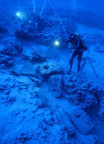
Uluburun, one of the oldest and wealthiest shipwrecks ever discovered


The Uluburun is a 3,300-year-old shipwreck discovered off the coast of Uluburun (Grand Cape), near Kaş in south-western Turkey. It is among the oldest ships ever discovered and contained one of the wealthiest and largest known assemblages of Late Bronze Age items found in the Mediterranean.  The ship was carrying over 20 tons of cargo, believed to be a royal order. In total, more than 18,000 spectacular artifacts have been recovered, including precious jewels, luxurious raw materials, and even the golden seal of Egyptian Queen Nefertiti.
The Uluburun was first discovered in 1982 by Mehmed Çakir, a local sponge diver, on a steep rocky slope at a depth of 44 to 52 metres, with artifacts scattered down to 61 metres.  Excavating it was a mammoth task, and required eleven consecutive campaigns of three to four months, conducted by the Institute of Nautical Archaeology, totalling 22,413 dives between 1984 and 1992.
The ship itself was 15 metres long and is the earliest known example of a ship constructed using the advanced mortise and tenon technique, where planks were joined by flat tongues of wood inserted into slots cut into the planks. The wood is Lebanese cedar, indigenous to the mountains of Lebanon, southern Turkey, and central Cyprus. The featured image is an accurate replica wreck of the Uluburun, showing how the ship would have once appeared.
The wreck site - Uluburun
The wreck site as viewed from the deeper end showing displaced anchors originally stowed near the bow. Credit: INA
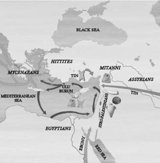
At the time of sinking, the ship was carrying over 20 tons of cargo, including both raw materials and finished goods, which have been traced back to at least seven different cultures, including Mycenaean, Syro-Palestinian (forerunners of the Phoenicians), Cypriot, Egyptian, Kassite, Assyrian and Nubian.
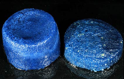
The main cargo was approximately 10 tons of primarily Cypriot copper in the form of 354 ingots. The Uluburun also contained the earliest known intact ingots of glass; 175 of disc-shape were recovered, which were coloured with cobalt blue, turquoise, and a unique lavender.
The earliest intact glass ingots of disc shape
The earliest intact glass ingots of disc shape. Chemical analyses have revealed the use of cobalt (left) and copper (right) as colouring agents. Credit: INA
Other raw materials included a ton of terebinth resin contained in around 150 Canaanite jars (most likely for incense), logs of Egyptian ebony, ostrich eggshells, elephant tusks, hippopotamus teeth, seashells, and tortoise shells.
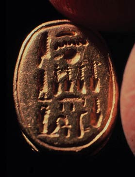
The finished goods were just as luxurious - Egyptian objects of gold, electrum, silver, and stone; Canaanite jewellery; thousands of beads made of glass, agate, carnelian, quartz, faience, and amber; and finely crafted figurines, including a bronze female statuette, partly clad in gold, of Syro-Palestinian origin.  One of the most unique and precious items was a scarab bearing the cartouche of Queen Nefertiti.
Egyptian scarab naming Queen Nefertiti
Egyptian scarab naming Queen Nefertiti. Credit: INA
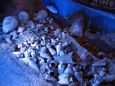
Other artifacts included ivory cosmetics containers, a trumpet carved from a hippopotamus incisor, bronze tools and weapons, lead net and line sinkers, netting needles for repairing nets, fishhooks, a harpoon, a bronze trident, and wooden writing boards. However, the largest group of manufactured goods on the ship was Cypriot fine- and coarse-ware ceramics.
Some of the Cypriot ceramics found on the Uluburun
Some of the Cypriot ceramics found on the Uluburun. Image source.
An analysis of the artifacts that were personal possessions of the crew members, such as tools, oil lamps, and writing boards, suggests that the crew were Canaanite and/or Cypriot, although at least two were Mycenaean.
The proveniences of the artifacts suggest that the Late Bronze Age Aegean was part of an international trade network perhaps based on royal gift-giving in the Near East, in which ships sailed the Mediterranean on a circular route from Syro-Palestine to Cyprus, onto the Aegean, and occasionally as far west as Sardinia, then back home via North Africa and Egypt.  
Trade routes in the Eastern Mediterranean during the Bronze Age
The Uluburun is considered one of the most important and fascinating sea wrecks ever discovered, and has provided archaeologists with an abundance of information about ancient society and culture across the Mediterranean, including Bronze Age ship building, sea routes, trading practices, and the production and exchange of raw materials and luxurious goods. Today, the remains of the Uluburun and its cargo are housed in the Bodrum Museum of Underwater Archaeology
Featured image: Replica of the Uluburun shipwreck. Image source.  

Global interest in the secret of Amphipolis

«η γη της Μακεδονίας μας εξακολουθεί να μας συγκινεί και να μας εκπλήσσει αποκαλύπτοντας από τα σπλάχνα της μοναδικούς θησαυρούς, που συνθέτουν, υφαίνουν όλοι μαζί αυτό το μοναδικό μωσαϊκό της Ελληνικής μας Ιστορίας, για το οποίο όλοι οι Έλληνες είναι πολύ υπερήφανοι».
Ταδε εφη ο πρωθυπουργος μας,ο πανταχου παρων και τα παντα πληρων.
Λογια με μεγαλη σημασια,που δινουν ενα ξεχωριστο μυνημα στις συγκυριες τις εποχης μας!
Global interest in the secret of Amphipolis

Global interest in the secret of Amphipolis


World is the most interesting for the important archaeological discovery in Amphipolis, Serres, details of which will see the light in the coming days, the newspaper said on its website DAILY. The visit of Prime Minister Antonis Samaras and statements purportedly made on the important findings there have generated much interest in the foreign media who have extensive offerings in the case.
All information converge, however, that the tomb are buried the lawful wife of M.. Roxanne Alexander and his son
The British network BBC to publish on the web site refers to a "breakthrough" and carries the statements of the Prime Minister, Antonis Samaras, that "the land of our Macedonia still moves us and surprises us by revealing the innards of treasures which compose, weave together this unique mosaic of our Greek History, for which all Greeks are very proud. "
According to the text of the experts believe that the tomb belonged to an important personality who dated between 325 and 300 BC
The BBC, in fact, adds that there is a rumor that an important personality of ancient Macedonia is buried in Tomb Castes and describes how the marble was transferred in special boats from Thassos
At the same time, and referred to the statements of Mr. archaeologist. Katerina pigeons, which stated that during the period dating burial precinct had been the exile and murder of Roxanne, lawful wife of Alexander the Great's son, Alexander D. .
The International Business Times on the other hand, refer to an important finding and transporting the reader to picture the majestic Sphinx guarding the tomb.
As for the French Le Figaro's website refers to the dimensions of the grave and the enclosure, but also for the famous lion of Amphipolis, and carries the statements of the Prime Minister and the archaeologist dove the importance of the discovery.
The Greek Reporter to publish refers to the "mystery of ancient Amphipolis" and wonders whether this is the tomb of a king.
Recall that the Prime Minister said this morning during a visit by urging people to do a few days of patience:
"It is clear that we face a very important finding," said the prime minister, Antonis Samaras, the Tomb of caste in Ancient Amphipolis, which was accompanied by his wife, Georgia, and Culture Minister, Costas Tasoula order to tour the area of ​​the excavation project.
Mr. Samaras added: "The earth of our Macedonia still moves us and surprise us by revealing the innards of the treasures that comprise weave together this unique mosaic of our Greek History, for which all Greeks are very proud. I am here for a monument with unique features: A precinct around 497 meters, almost a perfect circle sculptured in marble of Thassos. The Lion of Amphipolis over 5 meters, 5.20 meters, let's think on top of the mound. Two fully sculptured Sphinxes you see, is there like fylassoun- and indeed is there to preserve the entrance of the tomb. A wide road with a width of 4.5 meters, which leads to the entrance with walls that mimic a fresh way of building enclosure. I believe that all these factors have allowed Mr. Pigeons, the excavator, the archaeologist, is optimistic that this is a unique funerary monument, as we that- eipe- dated between 325 and 300 BC .. Of course, the key question is the excavation which would reveal the identity of the deceased.
The excavation will continue at a pace dictated by both the finding as, of course, and scientific ethics. Once again congratulations to Mrs. Pigeons and their partners. "
Speaking to ANA-MPA, the newly elected mayor Amphipolis Constantine Honey noted that "the visit of Prime Minister of the country means that something very big and important excavation has given" and added that "the region and all Greece will be known around the world.
According to the evidence so far presented -which the head of KH Ephorate of Prehistoric and Classical Antiquities Katerina pigeons, last March, at the 27th Scientific Planning Visit the archaeological past two years, in conducting excavations on the hill castes, revealed a unique grave yard in the world, due to its size of nearly five hundred feet, with exact proportions height of three meters and a total length of 497 meters, which dates to the last quarter of the 4th century. BC
In which store the last day of major police force, recorded strong mobility and reportedly the Ministry of Culture has been updated for all developments.
This unique funerary precinct because of its size which affects about five hundred feet, with exact proportions height of three meters and a total length of 497 meters, it evokes about who can be buried there.
We are in the middle of the excavation. Any dirt level, each 20 cm, and brings new data. We know about the context and general information. Information will be provided once the first phase of excavation, which will take place in a few days, "said Michael Lefantzis, architect of the First Ephorate of Prehistoric and Classical Antiquities, participating in excavations in the monumental courtyard of the Tomb Caste in Ancient Amphipolis.
"The official announcements have been made, give the answers. Whatever is found then those announced in archaeological conferences of 2013 and 2014 aim is to expose the monumental circular enclosure, which I have seen similar in my life, "he noted. Lefantzis.
Excavations
In June, after funding of € 100,000 from the Ministry of Culture, the excavations were stopped due to winter season continued, the head of the KH Ephorate of Prehistoric and Classical Antiquities, Katerina dove initially remove tons of soil that covers the hill castes, and then complete the excavation of the majestic cemeteries dating to the last quarter of the 4th century. BC
Mrs. Pigeons, talking to ANA, said that "during the period dating burial precinct, after the death of. Alexandrou by the end of the 4th century, major historical events happening in the area of ​​Amphipolis. Major generals and admirals of M. Alexandrou related area. Here Cassander banishes and kills in 311 BC the lawful spouse of M. Roxane and Alexander's son Alexander IV. "
Deinokratous
The burial yard dated around 325-300 BC and allegedly signed by the famous architect of that era Deinokratous, which according to historical data and was a close friend of M.. Alexandrou. Built by Thassian marble transported in special boats, while the marble domes of Thassos placed with special cranes, made ​​of wood, iron and lead, traces of which were found during the excavation.
According to archaeological research, a large part of the enclosure is dismantled in Roman times so many marble architectural members are not in place. A broader survey, conducted in the area of ​​Amphipolis in trying to locate the missing architectural members, led Katerina Pigeons and its partners in the area of ​​the monument, the Lion of Amphipolis, where the missing members of the precinct found either scattered or embedded on the basis of Leo. The dating of both cemeteries and Leo coincides belongs to the last quarter of 4 BC century.

Αρχαία Αμφίπολη: Δύο τοίχοι χωρίζουν τους ανασκαφείς από το μνημείο


Ο κ. Σαμαράς, που συνοδευόταν από τη σύζυγό του Γεωργία και τον υπουργό Πολιτισμού Κώστα Τασούλα, πρόσθεσε: «Η γη της Μακεδονίας μας εξακολουθεί να μας συγκινεί και να μας εκπλήσσει αποκαλύπτοντας από τα σπλάχνα της μοναδικούς θησαυρούς, που συνθέτουν, υφαίνουν όλοι μαζί αυτό το μοναδικό μωσαϊκό της ελληνικής μας Ιστορίας, για το οποίο όλοι οι Έλληνες είναι πολύ υπερήφανοι. 

»Πρόκειται εδώ για ένα μνημείο με μοναδικά χαρακτηριστικά: Ένας περίβολος γύρω-γύρω 497 μέτρα, σχεδόν ένας τέλειος κύκλος σμιλεμένος σε μάρμαρο Θάσου. Το λιοντάρι της Αμφίπολης πάνω από 5 μέτρα, 5,20 μέτρα, ας το σκεφτούμε στην κορυφή του τύμβου. Δύο ολόγλυφες Σφίγγες που βλέπετε, που είναι εκεί σαν να φυλάσσουν- και πράγματι είναι εκεί για να προφυλάξουν την είσοδο του τάφου. Ένας δρόμος πλατύς, με πλάτος 4,5 μέτρα, που οδηγεί στην είσοδο με τοίχους που μιμούνται σε φρέσκο τον τρόπο δόμησης του περίβολου. Πιστεύω ότι όλα αυτά τα στοιχεία έχουν επιτρέψει στην κ. Περιστέρη, την ανασκαφέα, την αρχαιολόγο, να είναι αισιόδοξη ότι πρόκειται για ένα μοναδικό ταφικό μνημείο, που- όπως μας είπε- χρονολογείται μεταξύ του 325 και του 300 π.Χ.. 

»Βέβαια, στο καίριο ερώτημα η ανασκαφή είναι αυτή η οποία θα αποκαλύψει την ταυτότητα του νεκρού. Η ανασκαφή θα συνεχιστεί με ρυθμούς που υπαγορεύει τόσο το εύρημα όσο, βέβαια, και η επιστημονική δεοντολογία. Για άλλη μια φορά συγχαρητήρια στην κ. Περιστέρη και τους συνεργάτες της».


Ο ίδιος, απευθυνόμενος προς τους κατοίκους της περιοχής με τους οποίους είχε σύντομη συνάντηση προτού μεταβεί στον χώρο της αρχαιολογικής ανασκαφής, τους συνέστισε με νόημα: «Κάντε υπομονή λίγες μέρες».

Σύμφωνα με πληροφορίες του Αθηναϊκού Πρακτορείου Ειδήσεων, ο Πρωθυπουργός, συνομίλησε με τους κατοίκους και στη συνέχεια μετέβη στον Τύμβο Καστά, όπου ξεναγήθηκε στον χώρο της ανασκαφής από την υπεύθυνη αρχαιολόγο Κατερίνα Περιστέρη και ενημερώθηκε για τα ευρήματα.

Ο κ. Σαμαράς έφτασε στην Αρχαία Αμφίπολη γύρω στις 9.45 το πρωί και έφυγε λίγο μετά τις 11.

Σε δηλώσεις του στο Αθηναϊκο Πρακτορείο Ειδήσεων, ο νεοεκλεγείς δήμαρχος Αμφίπολης Κωνσταντίνος Μελίτος σημείωσε ότι «η επίσκεψη του Πρωθυπουργού της χώρας σημαίνει πως κάτι πολύ μεγάλο και σημαντικό έχει δώσει η ανασκαφή» και πρόσθεσε ότι «η περιοχή και όλη η Ελλάδα πρόκειται να γίνει γνωστή σε όλο τον κόσμο».

Σημειώνεται ότι, οι ανασκαφές που διεξάγονται στον μοναδικό μνημειακό περίβολο του Τύμβου Καστά, στην Αρχαία Αμφίπολη, εικάζεται ότι βρίσκονται κοντά στην αποκάλυψη ενός σημαντικού τάφου.

Στον χώρο γύρω από την αρχαιολογική ανασκαφή παραμένει ισχυρή αστυνομική δύναμη.

Σύμφωνα με τα μέχρι τώρα στοιχεία -που παρουσιάστηκαν από την προϊσταμένη της ΚΗ' Εφορίας Προϊστορικών και Κλασικών Αρχαιοτήτων Κατερίνα Περιστέρη, τον περασμένο Μάρτιο, στην 27η αρχαιολογική επιστημονική συνάντηση- τα δύο τελευταία έτη, κατά τη διεξαγωγή των ανασκαφών στον λόφο Καστά, αποκαλύπτεται ένας μοναδικός ταφικός περίβολος στον κόσμο, λόγω του μεγέθους του, που αγγίζει τα πεντακόσια περίπου μέτρα, με ακριβείς αναλογίες ύψους τριών μέτρων και συνολικού μήκους 497 μέτρων, που χρονολογείται στο τελευταίο τέταρτο του 4ου αι. π.Χ.

Αρχαιολόγοι: Κάθε επίπεδο της ανασκαφής φέρνει νέα δεδομένα

«Είμαστε στη μέση της ανασκαφής. Κάθε χωμάτινο επίπεδο, κάθε 20 εκατοστά, φέρνει και νέα δεδομένα. Ξέρουμε περίπου το πλαίσιο και τα γενικά στοιχεία. Πληροφορίες θα δοθούν μόλις ολοκληρωθεί η α΄φάση της ανασκαφής που θα γίνει σε λίγες μέρες» δήλωσε στο ΑΠΕ-ΜΠΕ ο Μιχάλης Λεφαντζής, αρχιτέκτονας της Α΄ Εφορείας Προϊστορικών και Κλασικών Αρχαιοτήτων, που συμμετέχει στις ανασκαφές, οι οποίες διενεργούνται στον μνημειακό περίβολο του Τύμβου Καστά, στην Αρχαία Αμφίπολη.


«Οι επίσημες ανακοινώσεις, που έχουν γίνει, δίνουν τις απαντήσεις. Ό,τι βρέθηκε είναι η συνέχεια αυτών που ανακοινώθηκαν στα αρχαιολογικά συνέδρια του 2013 και 2014. Στόχος είναι να αποκαλυφθεί ο μνημειώδης κυκλικός περίβολος, που παρόμοιο δεν έχω ξαναδεί στη ζωή μου» επισήμανε.

Μέλος της ανασκαφικής ομάδας, που τάραξε για άλλη μια φορά τα νερά με τις πρόσφατες αποκαλύψεις, ο ίδιος -όπως και η κ. Περιστέρη- τηρεί σιγή ως προς τις τελευταίες. Ωστόσο, κάποια δεδομένα έχουν ήδη δει το φως της δημοσιότητας. Για παράδειγμα, η ανακάλυψη ενός υπερμεγέθους δρόμου που βρέθηκε στον λόφο Καστά, με ωραίους μαρμάρινους τοίχους, σε εξαιρετικό ψευδοϊσόδομο σύστημα, όπως του περιβόλου, καθώς και των δύο μαρμάρινων Σφιγγών, που όπως όλα δείχνουν φυλάνε έναν ξεχωριστό αρχαίο μακεδονικό τάφο, ο οποίος κρύβει ακόμα καλά τα μυστικά του.

Είναι επίσης σημαντικά όσα στοιχεία είναι ήδη γνωστά: ότι με την ψηφιακή σάρωση του 2013 ανακαλύφθηκε ότι ο περίβολος του τύμβου ήταν ένας ακριβής κύκλος και πως το μνημείο αποτελεί ενιαίο σύνολο με το Λιοντάρι της Αμφίπολης, που βρίσκεται πέντε χιλιόμετρα από τον τύμβο, κοντά στον Ποταμό Στρυμόνα, όπου μεταφέρθηκε περίπου 400 χρόνια από την ανέγερσή του από τους Ρωμαίους για την κατασκευή φράγματος.

«Όλα είναι μελετημένα με αναλογίες και γεωμετρική ακρίβεια, ενώ τόσο το Λιοντάρι όσο και ο τύμβος ανήκουν στην ίδια εργολαβία (σ.σ. κατασκευασμένα από το ίδιο εργαστήριο). Αποτελούν ένα τεράστιο ενιαίο μνημείο, άγνωστο ως σήμερα» επισημαίνει ο κ. Λεφαντζής, προσθέτοντας ότι αισθάνεται περήφανος που επιβεβαιώθηκαν όλα όσα είχε πει περί ενιαίου συνόλου ήδη από το 2012.

Επίσης, εξηγεί γιατί το Λιοντάρι έχει αυτή την όχι τόσο καλοσχηματισμένη όψη: «Επειδή βρισκόταν στην κορυφή του τύμβου, δηλαδή σε ύψος 35 με 40 μ. και σε απόσταση 100 μ. Αν το κάνεις φυσιολογικό δεν φαίνεται κανονικά από μακριά».

Για τον ίδιο και την ομάδα του είναι σαν να ζουν μια ανασκαφή των αρχών του περασμένου αιώνα και όχι του 2014. Επίσης, τονίζει πως αισθάνεται τυχερός που συμμετέχει σε μια τόσο καλά οργανωμένη ομάδα. «Χρειάζεται όμως να μείνουμε λίγο μόνοι από δω και πέρα για να δουλέψουμε πραγματικά. Η δημοσιότητα κάνει κακό. Πρέπει να είμαστε συγκεντρωμένοι σε αυτό που κάνουμε. Είναι δύσκολο έργο» διευκρινίζει.

Δύο τοίχοι χωρίζουν τους ανασκαφείς από το μνημείο

Mια ανάσα από τα κρυμμένα μυστικά του μακεδονικού τάφου που ανασκάπτεται στον λόφο Καστά της Αμφίπολης βρίσκονται οι αρχαιολόγοι. Σύμφωνα με έγκυρες πηγές του υπ. Πολιτισμού και Αθλητισμού δύο τοίχοι, μάλλον, χωρίζουν τους ανασκαφείς από το εσωτερικό του μνημείου στο υπέρθυρο του οποίου εντοπίστηκαν δύο αντικριστές σφίγγες-φύλακες με ίχνη χρώματος. Όμως το αποτρεπτικό βάρος του ενάμιση τόνου που ζυγίζει η κάθε μία απ’ αυτές δυσχεραίνει την «επιχείρηση», που δεν μπορεί να προχωρήσει παρά μόνο με σωστή οργάνωση ώστε να μην κινδυνεύσει με κατάρρευση.

Τα όποια ανοίγματα πρέπει να γίνουν αμέσως μετά τα 10 με 15 σκαλοπάτια της εισόδου που οδηγούν σε διάδρομο, κι αφού απομακρυνθεί μεγάλη ποσότητα χώματος στην είσοδο του μνημείου. Οι υπεύθυνοι εικάζουν ότι ένας δεύτερος τοίχος ακολουθεί σε απόσταση 6 με 7 μ. Όμως γι’ αυτήν τη διαδικασία, για την οποία θα βοηθήσουν οι μηχανικοί της υπηρεσίας -«είναι εξαιρετικά καλοί με πείρα», διαβεβαιώνουν από το ΥΠΠΟΑ-, απαιτούνται τουλάχιστον 15 με 20 ημέρες. «Σε πρώτη φάση πρέπει να καθαριστεί η είσοδος από το χώμα».

Τέλος Αυγούστου απάντηση για την Αμφίπολη

 «Θα ήταν άστοχο να μπούμε στον πειρασμό να κάνουμε εικασίες».

Μία ώρα μετά την ξενάγησή του στην Αμφίπολη των Σερρών, ο πρωθυπουργός Αντώνης Σαμαράς επιχειρεί να χαμηλώσει τους τόνους. Είναι και ο ίδιος εντυπωσιασμένος από όσα έχει δει νωρίτερα και δεν το κρύβει. «Όσα μας έδειξε η κυρία Περιστέρη και οι συνεργάτες της καταδεικνύουν τη σοβαρότητα των ευρημάτων».


Όμως, ο πρωθυπουργός δείχνει να μην επιθυμεί μια απότομη και υπέρμετρη κλιμάκωση των προσδοκιών. Παλαιότερα αρχαιολογικά «θρίλερ», εξάλλου, είχαν άδοξο τέλος και μας έχουν κάνει όλους πολύ πιο προσεκτικούς.

Πάντως, η χθεσινή ξενάγηση από την προϊσταμένη της ΚΗ΄ Εφορείας Αρχαιοτήτων Αικατερίνη Περιστέρη, παρουσία της συζύγου του Γεωργίας και του υπουργού Πολιτισμού και Αθλητικού Κώστα Τασούλα, προτετοιμάζουν και τον ίδιο τον πρωθυπουργό για κάτι «σημαντικό». Πόσο σημαντικό; Με δηλώσεις του ο Αντώνης Σαμαράς προτίμησε να καταγράψει τα δεδομένα. Ο κ. Σαμαράς δήλωσε στην «Κ» ότι πιθανότατα να έχουμε μια απάντηση μέχρι το τέλος Αυγούστου.

Το νέο αρχαιολογικό θρίλερ που εξελίσσεται τις τελευταίες ημέρες στη θέση Καστά Αμφίπολης έρχεται ένα χρόνο μετά την κατηγορηματική διάψευση της κ. Αικατερίνης Περιστέρη σε δημοσιεύματα που συσχέτιζαν τα ευρήματα με τον τάφο του Μεγάλου Αλεξάνδρου. Όπως σημείωνε η αρχαιολόγος, «είναι τουλάχιστον απίθανο και στερείται κάθε επιστημονικής σοβαρότητας το να υποστηρίζουμε πως το εύρημα της Αμφίπολης “κρύβει” τον τάφο του Μεγάλου Αλεξάνδρου. Για τον απλούστατο λόγο ότι, στον ένα χρόνο που διαρκεί η ανασκαφή, δεν σκάβουμε ακόμα τον τάφο. Προς το παρόν είμαστε μπροστά σε ένα λαμπρό ταφικό περίβολο – μοναδικό στον ελληνικό χώρο».

Τις ίδιες ημέρες υπήρξε και ανάλογη, «αποθαρρυντική» ανακοίνωση από το υπουργείο Πολιτισμού, με αποτέλεσμα το θέμα να ξεχαστεί.

Επανέρχεται σήμερα στην επικαιρότητα, καθώς οι αρχαιολογικές ανασκαφές σε εξέλιξη επαναδραστηριοποιούνται συνήθως τους καλοκαιρινούς μήνες.

Οι ανασκαφές στη θέση Καστά Αμφίπολης είχαν ξεκινήσει στη δεκαετία του ’60 από τον αείμνηστο Δ. Λαζαρίδη και συνεχίζονται τα τρία τελευταία χρόνια από την ΚΗ΄ Εφορεία Προϊστορικών και Κλασσικών Αρχαιοτήτων, με υπεύθυνη ανασκαφέα την προϊσταμένη Αικατερίνη Περιστέρη.

Η Αρχαία Αμφίπολη

Ο κύκλος

Μοναδικός σε διαστάσεις και σε επιμέλεια, χωρίς αντίστοιχό του στη Μακεδονία και στα Βαλκάνια, ο τύμβος της αμφίπολης φθάνει τα 23 μέτρα ύψος με 158,40 διάμετρο και περίβολο ύψους 3 μέτρων αποτελούμενο από μαρμάρινες βάσεις, ορθοστάτες, ανωδομή και επιστέψεις. Ολόκληρη κατασκευή δηλαδή, από λευκό καλοδουλεμένο μάρμαρο Θάσου, η οποία συγκρατείται στη θέση της από αντίθημα, δηλαδή αφανή τοίχο από πωρόλιθο έτσι που το συνολικό πάχος της κατασκευής να ανέρχεται σε 130 εκατοστά. Αυτός ο περίβολος εξάλλου για τον οποίο θα πρέπει να απαιτήθηκαν περί τα 2.500 κυβικά μαρμάρου είναι ένας τέλειος κύκλος κατασκευασμένος με απίστευτη γεωμετρική ακρίβεια, όπως επισημαίνει με θαυμασμό ο αρχιτέκτονας της ανασκαφής κ. Μιχάλης Λεφαντζής. «Αυτό το έργο υλοποιήθηκε από αρχιτέκτονα που είχε υψηλή γνώση της γεωμετρίας. Αρκεί να αναφέρω ότι χρησιμοποιεί το π: 3,14 αντί του 3,17 των Αιγυπτίων, που ήταν ως τότε σε χρήση» αναφέρει συγκεκριμένα.

Κατασκευασμένος στα τέλη του 4ου αιώνα π.Χ.  (325-300 π.Χ.) συμπίπτει εξάλλου ιστορικά «με μια εποχή κατά την οποία συμβαίνουν πολλά και δραματικά γεγονότα στη Μακεδονία και στην αμφίπολη ειδικά, με τις διαμάχες των επιγόνων του Αλέξανδρου και τον θάνατο της Ρωξάνης και του μικρού Αλέξανδρου Δ΄ κατόπιν διαταγής του Κάσσανδρου, ενώ παράλληλα στρατηγοί και ναύαρχοι του Μεγάλου Αλεξάνδρου σχετίζονται με την περιοχή», όπως λέει η κυρία Περιστέρη.

Το λιοντάρι

Με έκταση 20 στρεμμάτων ο τύμβος φέρει στην κορυφή του μία τετράπλευρη κτιστή κατασκευή (9,95 Χ 9,95 Χ 5,30 μέτρα), η οποία αρχικώς είχε θεωρηθεί από τον πρώτο ανασκαφέα Δ. Λαζαρίδη ταφικό σήμα. «Στην πραγματικότητα πρόκειται για το θεμέλιο του βάθρου επάνω στο οποίο βρισκόταν ο Λέων της αμφίπολης» λέει ο κ. Λεφαντζής. Η έρευνα του ιδίου σε συνεργασία με την Εφορεία Αρχαιοτήτων είχε ως αποτέλεσμα τον εντοπισμό 400 και πλέον μαρμάρινων αρχιτεκτονικών μελών γύρω από το άγαλμα που ανήκουν στον περίβολο του τύμβου (ορισμένα ενσωματωμένα στο βάθρο του λιονταριού).«Όλα τα μέλη του περιβόλου είναι της ίδιας τεχνοτροπίας με το λιοντάρι» επισημαίνει. «Για μένα μάλιστα η τυπολογία αυτού του περιβόλου δεν υπάρχει αλλού στη Μακεδονία. Αρχιτεκτονικά πρόκειται για ένα υβρίδιο». Όσον αφορά τον Λέοντα, «Με ύψος 5,30 μέτρα και συνολικό με το βάθρο του 15,84 μέτρα, έχει μακεδονικό εμβάτη με ημικίονες και ασπίδες στο βάθρο του» προσθέτει. «Επιπλέον είχε δημιουργηθεί με οπτική διόρθρωση, έτσι ώστε να είναι ορθά ορατός από απόσταστη 100 μέτρων και ύψος 30».

Σε απόσταση περί το ένα χιλιόμετρο από τη σημερινή αμφίπολη βρίσκεται η θέση Καστά όπου ανασκάπτεται ο τύμβος. Η γεωμορφολογία της περιοχής έχει αλλάξει ωστόσο ριζικά από την αρχαιότητα λόγω της διαφοροποίησης της κοίτης του Στρυμόνα και της αποξήρανσης της λίμνης Κερκινίτιδας. «Οι αρχαίες πηγές μιλούν όμως για τα ωραία αγκυροβόλια αυτής της λίμνης, η οποία συνδεόταν με το ποτάμι» λέει η κυρία Περιστέρη. Ένα ποτάμι πλωτό, που παρείχε τη δυνατότητα στα πλοία να φθάνουν ως την αμφίπολη. Όσο για τον τύμβο με τον Λέοντα, βρισκόταν ακριβώς μπροστά στη λίμνη. Προφανώς είχε τον λόγο του.

Στρατιώτες-αρχαιολόγοι

Δίπλα στην παλιά γέφυρα του ποταμού Στρυμόνα και πάνω στην επαρχιακή οδόαμφίπολης - Σερραϊκής Ακτής βρίσκεται σήμερα το τεράστιο μαρμάρινο λιοντάρι. Ιδού πώς και γιατί: η ιστορία αρχίζει έναν αιώνα πριν, στην περίοδο των Βαλκανικών Πολέμων, όταν έλληνες στρατιώτες κατασκευάζοντας μια γέφυρα στον Στρυμόνα θα εντοπίσουν και θα ανασύρουν μαρμάρινα αρχιτεκτονικά μέλη. Λίγα χρόνια αργότερα, τον Αύγουστο του 1916, άγγλοι αυτή τη φορά στρατιώτες που κατασκευάζουν οχυρωματικά έργα θα βρουν τα κομμάτια που έλειπαν: τα μαρμάρινα τμήματα ενός υπερφυσικού μεγέθους γλυπτού που είναι σαφές ότι πρόκειται για λιοντάρι. Αρχαιόφιλοι(!) όντες, επιχειρούν να τα μεταφέρουν στη θάλασσα για να τα στείλουν με πλοίο στην Αγγλία, αλλά οι Βούλγαροι έχουν άλλη γνώμη, καθώς έχοντας καταλάβει το Παγγαίο αρχίζουν να τους βομβαρδίζουν. Ο Λέων και το βάθρο του θα συγκολληθούν το 1936, κανένας όμως δεν είναι ευχαριστημένος με το αποτέλεσμα. Κάτι τους διαφεύγει...