Just 1.25 nautical miles from the southwestern Turkish coast and 72nautical miles east of the island of Rhodes lies Kastelorizo ormaximum, the easternmost tip of Elladas.Apo Piraeus is 328 nautical miles and 150 nm from Cyprus.
Has an area of 8.9 square km., 19,5 km coastline and a population of430 residents during the official 2001 census, the municipality that make up the Great. It is the largest (hence Great) small islandarchipelago that includes the rocky island St. George Agrielaia, BlackPunishment, Polyfado, Ro, Round, Bread, and some even Psoradiaislands (see List of islands of South Aegean region).
Kastellorizo connected by ferry (5 hours) and air (25 minutes) with Rhodes. The tiny airport is located 4 km from the port, which connectsthe only paved road on the island. Public transport is conducted in ataxi and a minibus, which operate on the route to the airport. The rest of the island explored on foot, through a network of natural trails. Forvessels operated refueling station at the port of Kastelorizo. There are still a post office, bank, medical center and several small shops for basic needs.


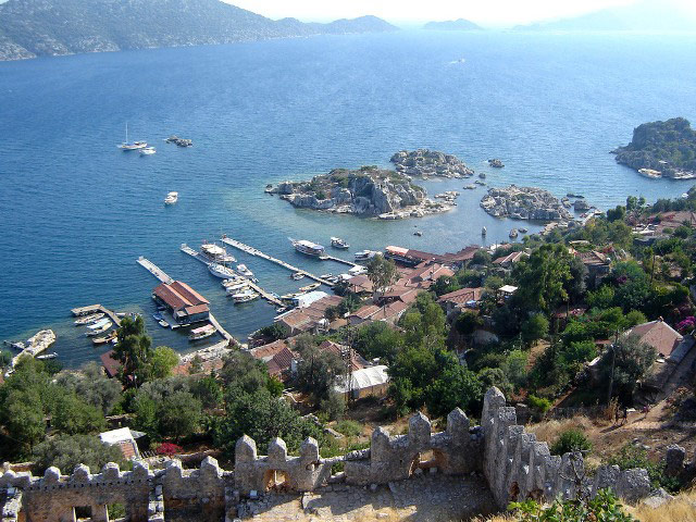
The only settlement on the island, Kastelorizo namesake, locatedaround the natural harbor and comprises the districts Wells, Fieldsand Mandraki. In the village there are many mansions, most of which have been deserted, as most residents have emigrated years ago in Australia.
The houses have been restored today are authentic examples of traditional architecture Dodecanese: amphitheater built around the water, causing the impression of uniformity, due to common materialssuch as stone and wood from Asia Minor, ironwork, tiles of Antalya andMarseille.
Impressively painted, two storey or three storey, the mansions alongthe shoreline in front of an imposing red rock. At the top, now a ruinedmedieval castle, built on the quays of the ancient Hellenistic era SosikliNikagora is what gave his name to the island (Castello Rosso, ie RedCastle). The traditional village of Kastelorizo is classified as preserved.
Αξιοθέατα [Επεξεργασία]

Ο οικισμός του Καστελλόριζου, στο βάθος τα μικρασιατικά παράλια
Η βάρκα αποτελεί το μοναδικό μέσο μετακίνησης προς δυσπρόσιτες ακτές και σπηλιές, αλλά και για τα γειτονικά νησάκιαΡω, Άγιος Γεώργιο και Στρογγυλή. Την αρχαία Αντίφελλο, το σημερινό Κας της τουρκικής ακτής, το αγναντεύει κανείς καθαρά από το λιμάνι, ενώ καθημερινά υπάρχουν σκάφη που μεταφέρουν τουρίστες εκατέρωθεν. Πέρα από το ιστορικό παρελθόν του, το νησί έχει να επιδείξει αρκετά αξιοθέατα, όπως:
- Το κάστρο των Ιπποτών του Αγίου Ιωάννη
Χτίστηκε τον 14ο αιώνα και σήμερα σώζονται μόνο τα ερείπια του κτίσματος, τα οποία βρίσκονται πάνω στο Καστέλο Ρόσο, τον κόκκινο βράχο απ’ όπου προέρχεται και η ονομασία του νησιού.
- Παλαιόκαστρο
Στη δυτική πλευρά του Καστελλόριζου βρίσκεται το σημαντικότερο και αρχαιότερο μνημείο του νησιού, το Παλαιόκαστρο. Πρόκειται για αρχαίο οικισμό με πολλά κτίσματα και δεξαμενές. Στη δωρική ακρόπολη του 3ου αιώνα π.Χ. σώζεται μια επιγραφή που περιλαμβάνει τον όρο Μεγίστη. Στην περιοχή, στη θέση Λιμενάρι, υπάρχουν και τα Κυκλώπεια Τείχη.
- Άγιος Γεώργιος του Βουνιού
Από το λιμάνι, 401 σκαλιά οδηγούν στον Άγιο Γεώργιο του Βουνού (ή Βουνιού). Βρίσκεται στην περιοχή του Παλαιόκαστρου και περιστοιχίζεται από τεράστιες φυσικές πλάκες. Μέσα στο μοναστήρι υπάρχει μια κατακόμβη, ο Άγιος Χαράλαμπος.
- Λυκιακός Τάφος
Πρόκειται για τάφο του 4ου αιώνα π.Χ., λαξευμένο στους πρόποδες του Κάστρου. Αξίζει να σημειωθεί ότι Λύκιοι ονομάζονταν οι κάτοικοι της περιοχής της Μικράς Ασίας, γιατί ο θεός τους, ο Λύκιος Απόλλωνας, λατρευόταν ως λύκος.

Πανοραμική άποψη του οικισμού
- Αρχαιολογικό και Λαογραφικό Μουσείο
Το Μουσείο στεγάζεται στο λευκό ιστορικό κτίριο πάνω από το αναπαλαιωμένο Τζαμί, κοντά στα ερείπια του Κάστρου. Στην εποχή τηςΦραγκοκρατίας, αποτελούσε τον εξωτερικό προμαχώνα του Καστέλο Ρόσο. Τα εκθέματά του περιλαμβάνουν αρχαιολογικά ευρήματα εκθέματα ανεκτίμητης αξίας από διάφορες περιόδους της αρχαιότητας, τοιχογραφίες του 17ου αιώνα, παραδοσιακές στολές, καθώς και αντικείμενα λαϊκής τέχνης.
- Γαλάζια Σπηλιά

Η είσοδος στη Γαλάζια Σπηλιά γίνεται με χαμηλή βάρκα και τους επιβάτες σκυμμένους.
Είκοσι λεπτά με το καΐκι από το λιμάνι βρίσκεται η Γαλάζια Σπηλιά του Καστελλόριζου. Γνωστότερη με τ’ όνομα «Σπηλιά του Παραστά» ή «Φώκιαλη», από τις φώκιες που κατοικούν μέσα, είναι το μεγαλύτερο από τα ενάλια σπήλαια της Ελλάδας και ένα από τα γνωστά παγκοσμίως για τον πλούσιο σταλακτιτικόστολισμό που διαθέτει. Βρίσκεται στο νότιο σημείο του νησιού και έχει μήκος 75m και ύψος 35m. Η είσοδος είναι συγκριτικά χαμηλή, στο ύψος μικρού καϊκιού.
- Μητρόπολη Αγίων Κωνσταντίνου & Ελένης
Στην πλέον περίοπτη θέση του νησιού, πάνω από το Μανδράκι, δεσπόζει ο μητροπολιτικός Ναός των Αγίων Κωνσταντίνου και Ελένης, συνυφασμένος με την κοινωνική και πολιτιστική ζωή του Καστελλόριζου από την ίδρυσή του (περί τα 1835) μέχρι και σήμερα. Ο ναός είναι χτισμένος σε ρυθμό τρίκλιτης θολωτής βασιλικής με πλούσια εικονογράφηση, μαρμάρινα τέμπλα και πανύψηλο μαρμάρινο καμπαναριό. Η στέγη της Μητρόπολης αυτής στηρίζεται σε δώδεκα μονολιθικούς γρανιτένιους κίονες, που μεταφέρθηκαν από το ναό του Απόλλωνα στα Πάταρα της Λυκίας, στην απέναντι Μικρασιατική ακτή.
- Νησάκι της Ρω
Στα νοτιοδυτικά του νησιού στέκει το μικρό νησάκι Ρω, που μπορεί κανείς να επισκεφτεί με ναυλωμένο καΐκι, γνωστό για την «Κυρά της Ρω», Δέσποινα Αχλαδιώτου (1898-1982), τη μοναδική του κάτοικο, που για δεκαετίες κάθε πρωί ύψωνε την ελληνική σημαία.